|
Zetas RIGHT Again
The Zetas have predicted that the Seaway will rip open further
during the New Madrid Adjustment, and that Wisconsin
and Michigan will tilt. Green Bay developed
a hum in 2008, and booms throughout Wisconsin from Clintonville through Montelo to
Baraboo occurred in 2012. A crevasse
appeared in the Michigan peninsula in 2010, growing to
this day. Chicago is expected to be devastated during the New
Madrid process.
ZetaTalk Prediction 9/28/2013: Prior
to the Pole Shift the New Madrid adjustment will also tear
Wisconsin. The New Madrid Fault Line runs past Chicago and
then below the Great Lakes through Ohio. The rock structures
that are holding the Seaway together will be weakened.
Michigan, near Detroit, has a regular hum from stressed rock.
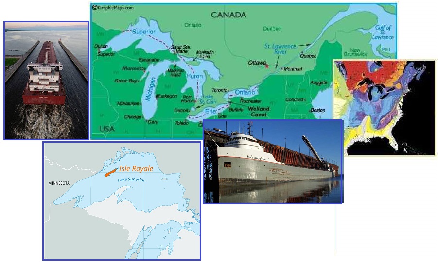
So what caused the good ship Michipicoten
to run aground in Lake Superior on June 8? This is another
example of Zetas RIGHT Again on an expanding Seaway, and the
Seaway Path though Lake Superior. The Zetas explain.
- Freighter Ship in Lake Superior
Collides with Underwater Object, U.S. Coast Guards Says
June 8, 2024
https://torontosun.com/news/world/freighter-ship-in-lake-superior-collides
- The Michipicoten had collided with
something about 56 kilometres southwest of Isle Royale,
which is part of the state of Michigan. The ship was
carrying taconite, which is a low-grade iron ore, and had
22 people aboard. Water pumps onboard began displacing
water, authorities said, and there were no signs that
anything spilled from the ship. By 9:15 a.m., water pumps
had reduced the listing of the freighter from 15 degrees
to 5 degrees. Authorities say the cause of the collision
will be investigated.
- Freighter taking on Water after
Underwater Collision on Lake Superior
June 8, 2024
https://www.stripes.com/branches/coast_guard/2024-06-08/freighter-ship-underwater-collision-lake-superior-14120841.html
- Isle Royale is about 20 miles east
of Grand Portage, Minn., just south of the Canadian
border. It’s not immediately clear whether the ship is in
Minnesota or Michigan waters.
ZetaTalk Confirmation
6/9/2024: We
have detailed how the New Madrid Adjustment will alter the
path of the Seaway, bypassing Lake Erie by going from Lake
Ontario to Lake Huron. Meanwhile the top part of Michigan will
lob to the West and Wisconsin will find its Green Bay
expanding. What changes might Lake Superior experience?
We explained why the Seaway path avoids
Wisconsin by running through Lake Superior, and thence
out beyond Duluth to the rumpled Black Hills. The Seaway is
taking the easy path along rock strata that allows
ripping.
Shipping channels are selected
for being a direct line between ports when possible, and only
secondarily for being deep water. Both Isle Royale and Thunder
Bay are not in deep water but are more akin to a fracturing
shore line. As the Seaway widens, there will be more
room for the water and thus the overall depth of the Great
Lakes will drop, exposing the rocky bottom. This is what
happened to the Michipicoten. The Coast Guard will have to
update their depth charts. This is another example of Zetas
RIGHT Again re the Seaway path and a widening Seaway.
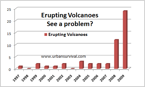
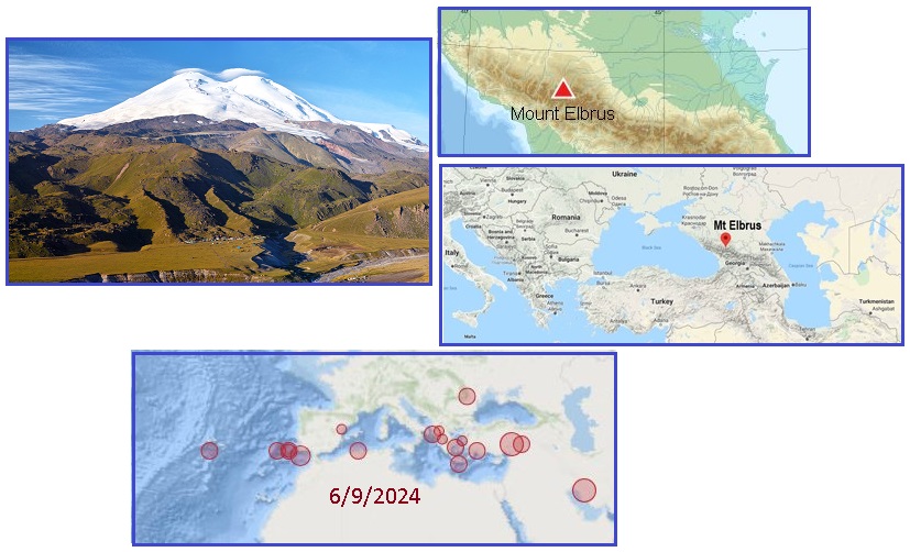
Mount Elbrus
Volcanoes have awakened during the
Plate Movements. Even inactive volcanoes
have been regularly joining the chorus.
ZetaTalk Prediction
2/15/2000: All
volcanoes that have been active within the memory of man will
begin spewing and burping and oozing, and many that were not
expected to become active will reactive. We have stated that
all volcanoes active within the last 10,000 years can be
considered candidates to blow, or ooze during the shift.
Mount Elbrus certainly qualifies as a volcano that will erupt,
at least during the coming Pole Shift. The Plate Movements have
caused active and dormant volcanoes
to erupt and ooze already. The Zetas have stated that all
volcanoes active in any way within the past 10,000 years will
erupt, and Mount Elbrus was active 2,000 years ago. Mount Elbrus
lies in a highly active region, subject to the Africa Roll and
stretching Eurasian Plate, both ongoing during the New Madrid
Adjustment time.
- Mount Elbrus
https://en.wikipedia.org/wiki/Mount_Elbrus
- Mount Elbrus is
the highest
mountain in Russia and Europe. It is
situated in the western part of the North
Caucasus and is the highest peak of the Caucasus
Mountains. Mount Elbrus was formed more than 2.5
million years ago. The volcano is currently considered
dormant. Elbrus was active in the Holocene, and
according to the Global Volcanism Program, the last
eruption took place about AD 50. Evidence of recent
volcanism includes several lava flows on the
mountain, which look fresh, and roughly 260 square
kilometres (100 sq mi) of volcanic debris. The
longest flow extends 24 kilometres (15 mi) down the
northeast summit, indicative of a large eruption. There
are other signs of activity on the volcano,
including solfataric activity and hot
springs.
ZetaTalk Prediction
6/7/2024: We
have stated that all volcanoes active within the last 10,000
years will become active during the forthcoming Pole Shift, as
many were during the current Plate Movements. The Alps were
raised high during previous Africa Rolls, as have the
mountains in the Caucasus range. But where the Alps are
dormant at present the Mt Elbrus region is being aggressively
stretched during this current passage of Nibiru.
Where a stretch should relieve pressure, it can also open new
pathways between Magma chambers and the surface. In that Mt
Elbrus has had lava flows within the past 2,000 years, it
should be considered an active volcano, with an open path to
the surface. If such a lava flow is deep and wide, this could
result in the immediate 100 mile radius of Mt Elbrus to prove
dangerous, as is our advice for all active volcanoes. We have
mentioned that the Black Sea will
open to the Mediterranean during the Pole Shift, but without
trauma for those living on the shores of the Black Sea. But we
have also cautioned that Istanbul
can expect disaster during the stretch caused by the Africa
Roll during the current New Madrid Adjustment.
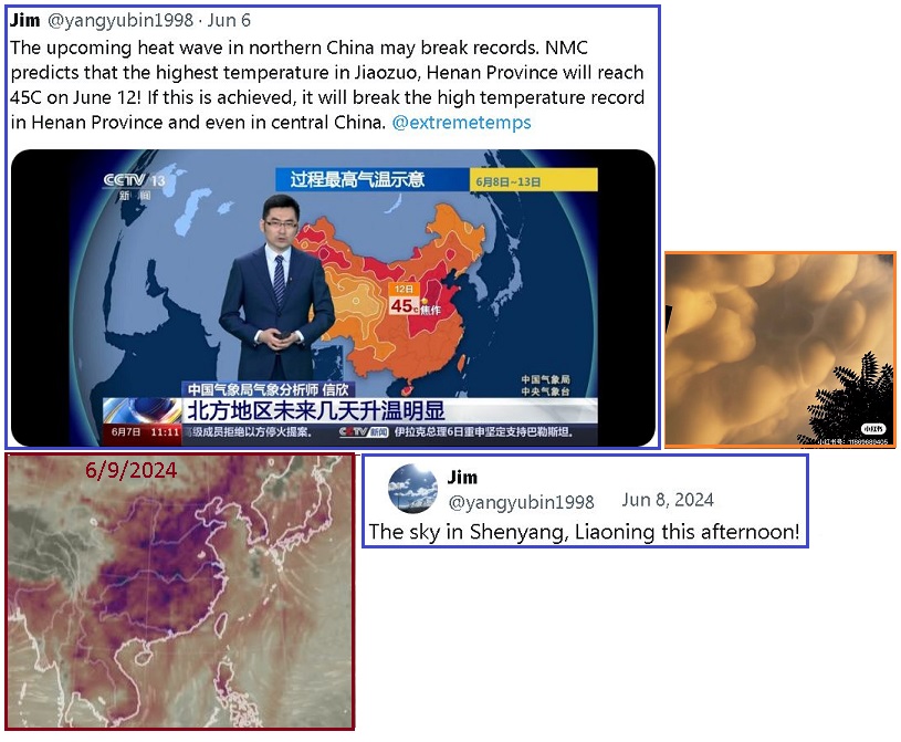
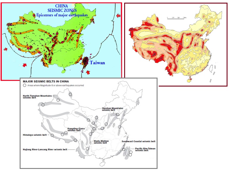
China Blowout
Pending
Over the past few years China has been stretched taut,
resulting in the release of Methane from rotting vegetation
between the rock layers. Roads melted, school children in
Beijing were hospitalized due to Methane poisoning, and a Zeta
analysis of UFO displays in the Triangle formed by Japan,
Taiwan, and Beijing indicated a Beijing blowout was
pending. Now in addition to a heat wave, Beijing is
getting Mammatus
Clouds overhead.
- Mammatus Clouds
https://en.wikipedia.org/wiki/Mammatus_cloud
- They are usually composed of ice,
but also can be a mixture of ice and liquid water or be
composed of almost entirely liquid water. True to their
ominous appearance, mammatus clouds are often
harbingers of a coming storm or other extreme weather
system. Typically composed primarily of ice, they can
extend for hundreds of miles in each direction and
individual formations can remain visibly static for ten to
fifteen minutes at a time.
ZetaTalk Confirmation
6/10/2024: Mammatus
cloud forebode thunderstorms but is there a nexus for Beijing
between the heat wave being suffered there and the signs that
China is burning from methane released from the ripping rock?
The sustained heat that ripping rock produces, when the
Methane burns, can indeed result in a heat wave.
China has been stretched over the past few years, causing
methane release with melting roads and methane poisoned school
children in Beijing and a roaring dragon in the mountains due
to solid rock vibrating when being pulled apart. The fault
lines in China converge on Beijing, avoiding the big belly. So
when any China Belly Blowout occurs, Beijing will be at the
center.
New Madrid Creep
Since last reported, the New Madrid Adjustment can be measured
in disasters within the SE and Mainland Portions in the US and
even in Spain and Istanbul. Bridges and buildings have
collapsed, water mains are breaking, and a barge grounded in
Lake Superior. The US Military sends surveillance planes aloft
when the stretch pulls the ground low, as an indication of how
concerned then are about all this. The Africa Roll is part of
the Plate Movement process, as is New Land rising near
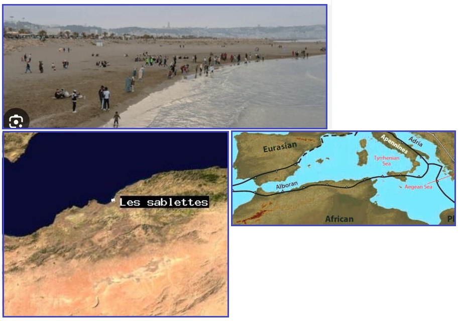
Antarctica. Over the past month, here are the highlights. On May
11 the Africa Roll took some victims in Algeria due to Methane
poisoning on the beach. The plate border between the Africa
Plate and Eurasian Plate runs smack through that beach in
Algeria.
- The Dangers of Methane Gas Poisoning
and Exposure
https://nevadanano.com/methane-gas-poisoning-and-exposure/
- Methane exposure, particularly
when experienced in high concentrations, can lead to
methane gas poisoning. While it is considered relatively
non-toxic, its primary threat is that it functions as an
asphyxiant, similar to the threat posed by carbon monoxide
exposure. When inhaled, it displaces ambient air, thus
depriving the body of oxygen needed to breathe.
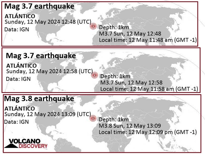
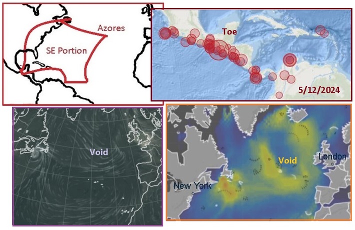
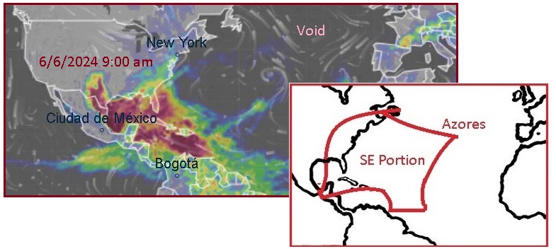
On May 12 we see that the SE Portion is very much on the move!
The Toe of the SE Portion at the Isthmus is being ripped away,
with a Mag 6.2 quake at the tip of Mexico. The Void where the
Eurasian and Mainland Portion are expected to pull apart to
facilitate the tsunami wave rebound toward Europe has been the
center of activity in the N Atlantic for a week, and remains
that way on May 12 with the Gulf Stream diverted. The Wave map
also shows the water being pushed away from the Void due to the
heat of the rock rupture.
On May 24 Godzilla arose again where the New Land predicted by
the Zetas is expected to rise. Once again, a software glitch
assumed this was a storm so indicated these huge waves would
roar North, but the projections were quickly
squelched. But the ice on the Brunt Ice Shelf was not a
quirk, breaking off as the Antarctica Plate is shoved up.
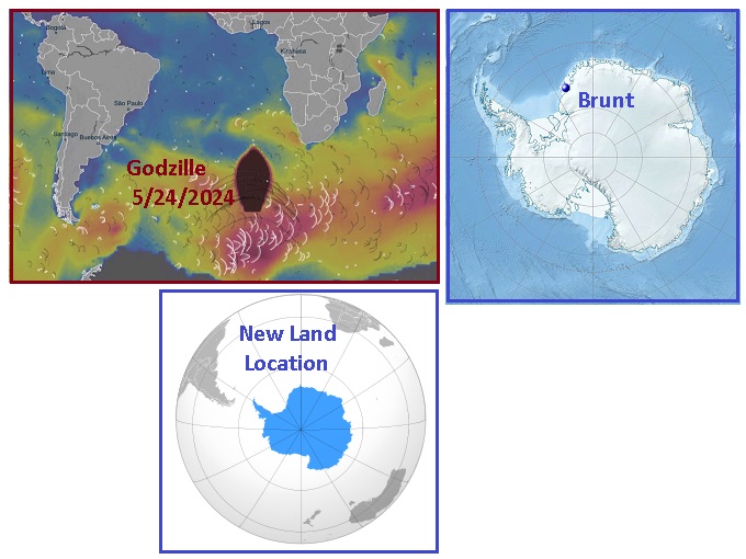
- Brunt Ice Shelf in Antarctica Calves
New Iceberg
May 21, 2024
https://www.bas.ac.uk/media-post/brunt-ice-shelf-in-antarctica
- The iceberg calved after a
14km-long chasm formed at ninety degrees to the existing
Halloween Crack. This follows a long period of
weakening of the ice at the McDonald Ice Rumples. The
break off is the third major iceberg calving from this
area in the last four years and has taken place around a
decade after scientists at British Antarctic Survey (BAS)
first detected growth of vast cracks in the ice.
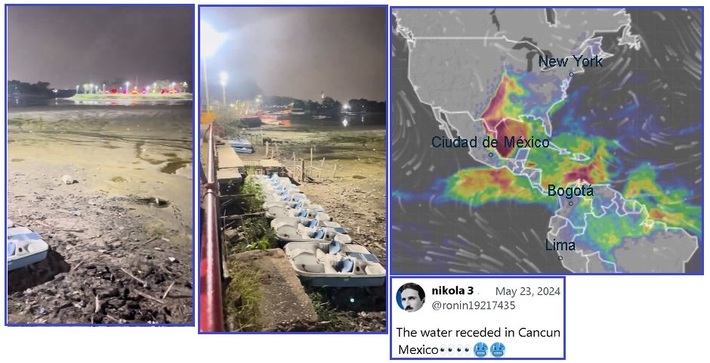
On May 24 we find confirmation that the New Madrid Fault Line
is aggressively separating in the Gulf of Mexico. The sinking
land on either side of the fault line shows that the land has
support on only one side, not on all sides as formerly. Thus the
sinking Gulf creates low air pressure which caused the Houston
TX storms weeks ago. Thus the water has more room, a place to
flow into the new void of the Gulf, so pulls away from the beaches
at Cancun.
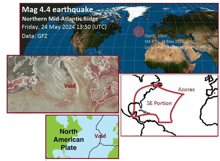
But all eyes are still on the Void which is expected to open
along the Eurasian/N American border in the N Atlantic. This is
predicted to clap so broadly at one point that the Gulf Stream
water will bounce in and out, sending a tsunami to Europe. On
May 24 we see the Gulf Stream swirling around the Void region,
with a sizable Mag 4.4 quake right on the Void.
On June 2, another Zetas RIGHT Again episode occurred in
Istanbul as a building collapsed. Disasters are just
starting for Istanbul as the Africa Roll has a long way to go
yet.
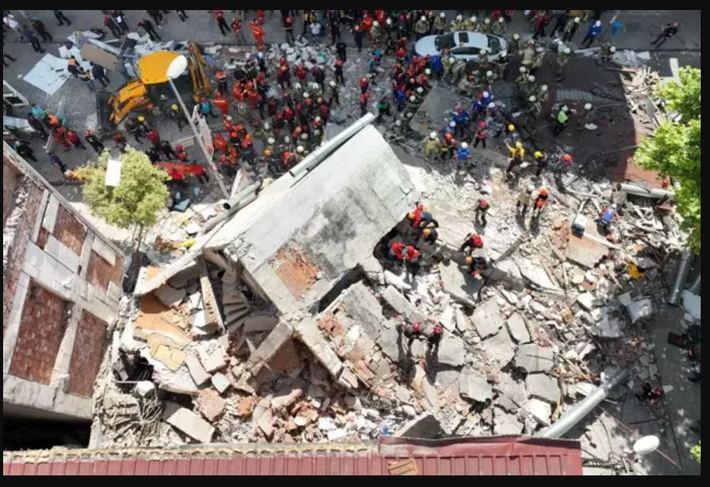
- Istanbul Building Collapse Leaves One
Dead, Several Others Injured
June 2, 2024
https://www.hurriyetdailynews.com/amp/fatal-building-collapse
- An apartment building on June 2
collapsed in Istanbul's Kekmece district, killing one
resident trapped under the rubble, with teams rescuing
eight people.
ZetaTalk Prediction
3/25/2011: When
the 7 of 10 scenario for Africa occurs, dropping Africa and
widening the Red Sea, the isthmus holding Istanbul will tear,
dropping the city into rubble.
On June 3 there was a dam failure at the Rockwall Dam near
Dallas. This is an earthen dam that moved 6 feet within 24
hours, forcing an evacuation below the dam. This was another
Zetas RIGHT Again as the Zetas had predicted the substrata in
the soil around Dallas would
melt in the presence of water. The Rockwall Dam failure was
followed by an Angel Lake Dam failure in northern Nevada.
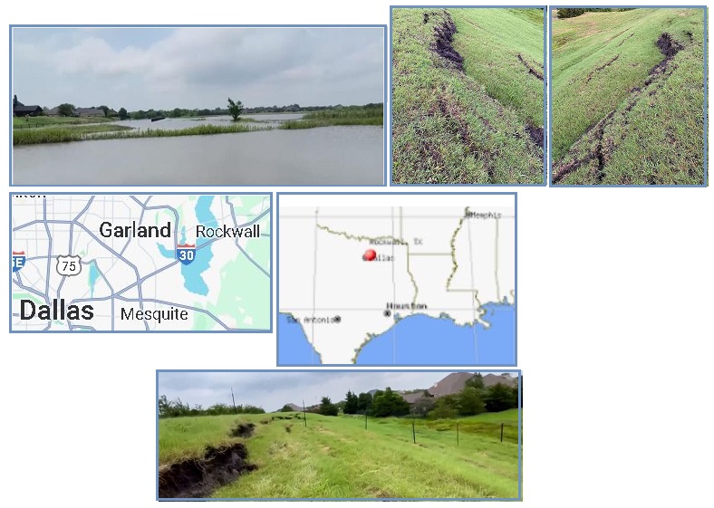
- Saturated Land Leads to Erosion
Concerns at a Dam in Rockwall County
June 3, 2024
https://www.nbcdfw.com/news/local/rockwall-county-dam
- After Sunday’s heavy rain that
fell across much of North Texas, emergency officials
continue to monitor the integrity of an earthen dam in the
Rockwall County community of McLendon-Chisholm. According
to Mayor Bryan McNeal, the pressure caused the ground to
shift approximately six feet in the last 24 hours,
heightening concerns over a possible dam failure.
- State says 'No Immediate Danger' after
Rockwall Co. Dam Shifts Feet
June 3, 2024
https://www.wfaa.com/article/weather/rockwall-county-texas-dam
- A dam in Rockwall County
in the McLendon-Chisholm area shifted six feet in 24
hours, but posed no immediate danger.
ZetaTalk Confirmation
6/3/2024: We
warned that the substrata of land around the Dallas
area would melt when flooded and under the drooping land
phenomena that developed in May 2024 this has proven true.
Zetas RIGHT Again! Drooping land creates a low air pressure
system overhead, thus thunderstorm development. The saturated
land at the Rockwall earthen dam is giving way. This will soon
be a concern for all areas on the Mainland to the West of the
Mississippi River, where drooping presents not only
Thunderstorms but poor drainage for the rain that develops.
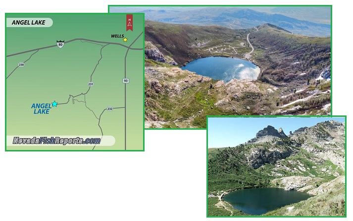
- Cracks in One of Nevada’s Oldest Dams
force Rangers to Limit Campground Access
June 14, 2024
https://www.8newsnow.com/news/local-news/cracks-in-one-of-nevadas
- Cracks in one of the state’s
oldest dams have prompted rangers to limit access to Angel
Lake campground in Northern Nevada and crews are working
to make repairs. Forest officials have asked the public to
avoid the Angel Lake area until emergency stabilization
work is completed. If the dam does fail, a large flow of
water could take a lot of sediment downstream and cause
damage to the watershed. The dirt-and-rock dam was built
in the 1880s. The area is southwest of Wells, Nevada,
where Interstate 80 and U.S. 93 meet. It’s one of the most
scenic areas of the state, not far from Lamoille Canyon in
the Ruby Mountains. Angel Lake is 6 hours north of Las
Vegas.
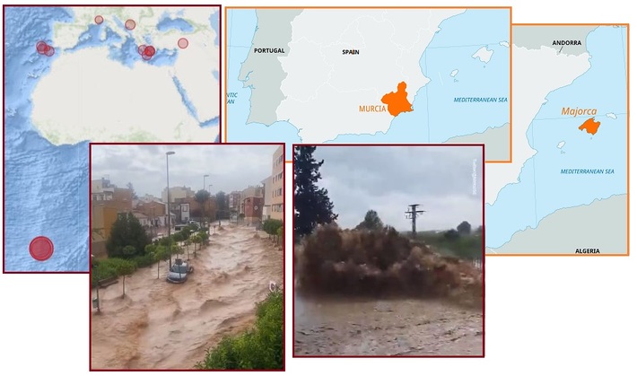
On June 14 we were reminded that the New Madrid Adjustment
affects more than just N America. As Africa Rolls, pulling its
foot into the S Atlantic, the top nob of the Africa Plate pulls
to the East, widening the Gibraltar gap, and tearing the border
between the Eurasian Plate and the Africa Plate. This means the
border between these two plates has less support, and will
droop, such that flood water will flow in the direction of the
drooping border in the Mediterranean. Tilt a table and the
contents will slide to the lower side. Tilt a plate border and
the same thing occurs, water seeking its level. This
occurred for the island of Majorca
and Murcia
in Spain.
On June 13 extensive flooding occurred in southern Florida. As
the SE Portion is pulled along with Africa during its roll, the
stretch causes land to droop. This shows up on air pressure maps
as Thunderstorm potential, as drooping land creates a void
there, so high pressure regions rush in – the classic
Thunderstorm dynamic. The rain that resulted caused immense
flooding in Florida on June 13.
ZetaTalk Confirmation
6/9/2024: After
2-3 weeks of dramatic Mainland drooping to the west of the
Mississippi River, this pattern suddenly switched to drooping
over the SE Portion. During Plate Movements, many plates are
in a dance, a twitch in one can result in a twitch in another.
The S America waggle has been active, with the Nazca Plate
pushed into the Pacific. The Caribbean Plate is being snagged
and pushed down by the S America Roll to the West. The Africa
Roll continues daily, moving the foot of Africa into the
Atlantic. When all this frees the Toe of the SE Portion so it
can slide over the Caribbean Plate border, dramatic changes
can result.
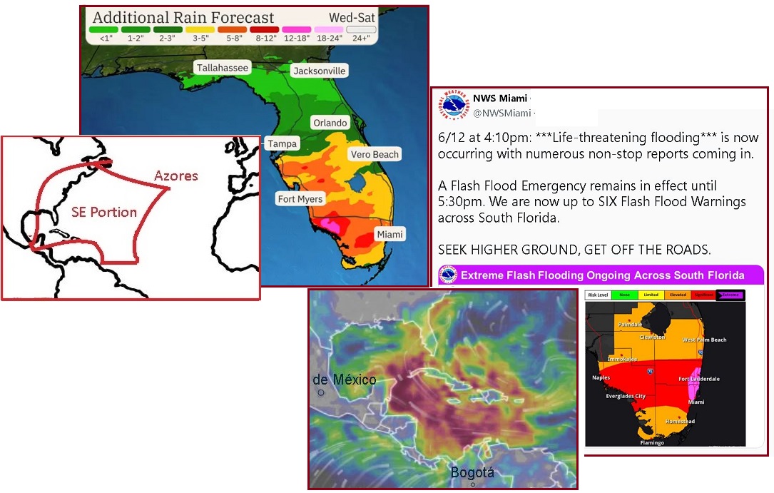
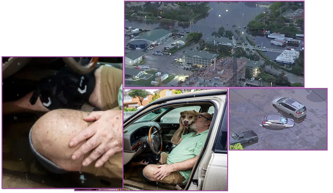
- Heavy Rain and ‘Life-Threatening
Flooding’ hit South Florida, Prompting the Governor to
Declare an Emergency
June 13, 2024
https://www.cnn.com/2024/06/11/weather/florida-flooding-hurricane-season
- Multiple communities across South
Florida — including the Miami and Fort Lauderdale areas —
flooded amid bouts of torrential rain that prompted the
state’s governor to declare an emergency and stranded
drivers across the region. Footage on social media showed
water levels in the area reaching to vehicles’ windows and
filing up parking decks and neighborhood streets. In
Miami, video showed stranded cars that were nearly
entirely submerged under water. It’s the second
consecutive day the Miami area has faced down flooding
issues.
|