|
Orange Snow
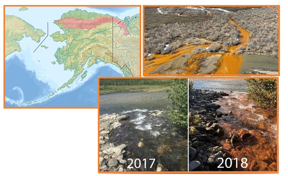
Why would Alaska rivers in the Brooks Range start to turn
orange? Over the past 10 years, some 75 rivers have changed
color from being a clear mountain river to a solid orange color.
Scientists are bumfuzzled but the Zetas, as usual, explain.
- 75 Alaskan Rivers Turn Bright Orange,
Tainting Water Supply, Endangering Humans and Wildlife;
Scientists Investigate
December 20, 2023
https://www.msn.com/en-us/weather/topstories/75-alaskan-rivers
- The problem is particularly
prominent in the Brooks Range, a 700-mile mountain range
that stretches from northern Alaska
into Canada's Yukon Territory. At least
75 rivers and streams in the area have become
tinted bright orange in the past five to 10
years. The problem is believed to be a consequence of
thawing permafrost due to climate change. The
discoloration is the result of oxidizing iron and sulfuric
acid, indicating the rivers are being inundated with high
concentrations of heavy metals.
- Rust
https://en.wikipedia.org/wiki/Rust
- Rust is an iron oxide, a usually
reddish-brown oxide formed by the reaction of iron and
oxygen in the catalytic presence of water or air moisture.
Rust consists of hydrous iron(III) oxides
(Fe2O3·nH2O) and iron(III) oxide-hydroxide (FeO(OH),
Fe(OH)3), and is typically associated with the corrosion
of refined iron.
ZetaTalk Confirmation
12/20/2023: The
Red Dust in the tail of Nibiru has been known to appear as
Orange Dust on snow in the Arctic in 2007 and 2018. Both Red
and Orange are shades of rust. The addition of water to Iron
Oxide dust produces Orange rust. The Arctic Circle has a
plethora of snow, and water trapped in the snow is thus
present. Now that the Daily Earth Wobble has gotten more
extreme, warmer temperatures are melting the mountain snow and
lo, the rivers have become orange.
Orange Snow has appeared in the past at Sochi
in 2018, and was a puzzle then too.
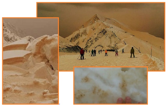
- Freak Weather: Orange Snowstorm
Submerges Tourist Resorts with Eerie 'Apocalyptic' Scenes
March 25, 2018
https://www.express.co.uk/news/weird/936514/Freak-weather-Orange-snowfall-tourist-ski-resort-Russia-Sochi
- Cities around Russia, Ukraine,
Bulgaria and Romania have all reported the bizarre orange
snow phenomenon, videos of which have quickly gone viral.
Tourist destinations, including ski resorts, have been
blanketed by the orange snow, which has turned snowy
mountains into sand dunes. The snow phenomenon has been
compared to a similar incident that took place in Siberia
in 2007 when orange-tinted snowfall covered 1,500 square
kilometres. According to Russia's environmental watchdog
at the time, the snow was reported to be "malodorous, oily
and contain four times the normal level of iron".
All these phenomena would easily be explained if Nibiru were
admitted. But without the Nibiru connection, they remain a
puzzle. Increasingly, in step with the release of the new
NetFlix film Leave the World Behind, internet forums are
admitting the Nibiru presence. The Shadow
of Ezra site did so with a photo that has several clues to
Nibiru’s presence. Who can resist a puzzle!
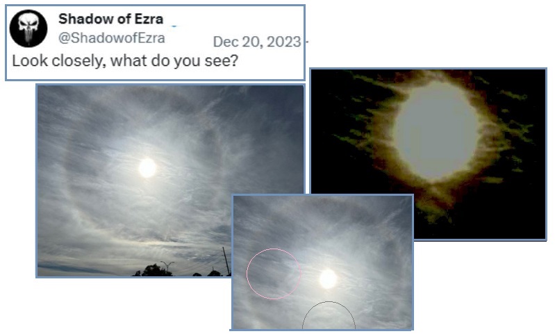
ZetaTalk Confirmation
12/20/2023: Nibiru
is most obvious at sunrise and sunset when the angle of
sunlight bouncing off Nibiru produces the Second Sun
phenomena. Nibiru is so shrouded by Red Dust and Petrol fog
that it is hard to discern during an eclipse, but enhancing
the photos can bring it out. The Petrol in the tail of Nibiru,
now wafting the Earth and producing dramatic rainbow clouds,
is another proof of the Nibiru presence. In Ezra’s photo one
finds Nibiru at the 6 o’clock position, the tail wrapping
around in a clockwise direction to show Red Dust at the left
of the Sun, and an uneven Sun Halo where the Sun is not
centered within the Halo. Ezra knows the time of Nibiru has
arrived, and as he is a source of truth, is heralding its
arrival.
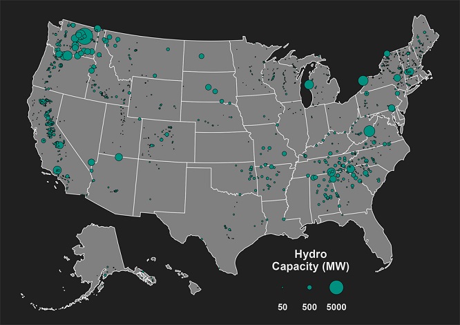
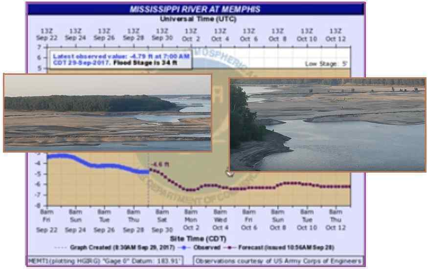
Hydro-Electric
Vulnerable
The Zetas have described the effect of the New Madrid Rupture
on the lower Mississippi River and the Seaway. These giant
waterways have a number of hydro-electric plants that would
certainly be affected. There are currently 20 hydro-electric
dams along the Mississippi River and 16 hydro-electric
generating stations along the St Lawrence. When low-water
conditions occur on the Mississippi, sand bars block
navigation. It does not take much to slow the flow. A heaving
river bed can occur and can even divert the course of the river
to meander to a new location.
ZetaTalk Confirmation
12/31/2023: When
the SE Portion is pulled away from its current position, the
New Madrid Rupture will widen the Mississippi River by up
to 50 miles in some places below the Illinois border.
Thus the water level can be expected to drop below the level
needed by any hydro plants along that stretch of the
Mississippi. The Seaway is dependent upon the flow of water
from the water basin that feeds the Great Lakes. The Seaway
will divert away from Lake
Erie, taking a bypass from Lake Ontario to Lake Huron, so any
hydro plants below this bypass might be disabled.
- Mississippi River ran Backward?
http://www.showme.net/~fkeller/quake/mississippi_river
- A "thrust fault" uplift dammed the
Mississippi for a few hours early on the morning of Feb.
7, 1812 from about Island #10 north past island #9. There
were temporary river waterfalls where the Mississippi ran
backwards during 1811-12 earthquakes. It happened when a
thrust fault created a sudden dam several feet high near
the bottom of the river loop near New Madrid. Ask the
boatmen who were rudely awakened in the middle of the
night. "In a moment, so great a wave come up the river
that I never seen one like it at sea. It carried us back
north, up-stream, for more than a mile. The water spread
out upon the banks -- covering three or four miles inland.
"It was the current going backward. Then this wave
stopped, and slowly the river went right again.
"Everywhere there was noise like thunder. The ground was
shaking the trees down. The air was thick with something
like smoke. There was much lightning.
- Eyewitnesses to Mississippi River
Earthquake Terror
http://www.showme.net/~fkeller/quake/lib/eyewitness
- "...the water ran 12 feet
perpendicular... Another fall was formed about 8 miles
below the town, similar to the one above, the roaring of
which he could distinctly hear at New Madrid…" "...from
the deck of the primitive boat she saw the rapid current
of the Mississippi suddenly change its course and run with
racehorse speed, up-stream, accompanied by a sound like
the most terrific thunder..." "The current of the
Mississippi was turned back till the accumulating waters
gained sufficient force to break through the newly raised
barrier…" "...we saw a sandbar form below us, that
extended clear across the river, & the water commenced
rolling in terrific waves up the current & broke our
boat loose... This bar lasted only a short time; in a few
hours the retrograde current soon spread over it again..."
ZetaTalk Confirmation
2010: As
can be seen by an analysis of the rock strata to the east and
west of the Mississippi, the Mississippi is following the
curve of solid rock just to the east. The potential for a
greatly widened Mississippi occurs south of the Illinois
border. To the south of this point the sea level elevation is
lower and the rock strata is of a different nature than that
above or to the east of this point. This is where the
Mississippi will spread, to the west between the Illinois
border and the Mississippi delta. We estimate the Mississippi
will widen by 50 miles, give or take depending on its
meandering and the stability of the rock or soil in any given
location.
ZetaTalk Confirmation
2012: We
have warned that during the 7 of 10 New Madrid scenario, that
most bridges crossing the Mississippi will be torn. Land to
the west of the Mississippi is expected to drop, so that the
river widens by 50 miles from the Illinois border
south to the Gulf.
Then there is the St Lawrence Seaway, which likewise will
experience trauma. It will be ripped open during the New Madrid
Rupture, but Niagara Falls will keep its current course until
the Pole Shift. But the Zetas have described a changed route as
the Seaway waters move through the Great Lakes. They predict the
route will go from Lake Ontario to Lake Huron, bypassing Lake
Erie.
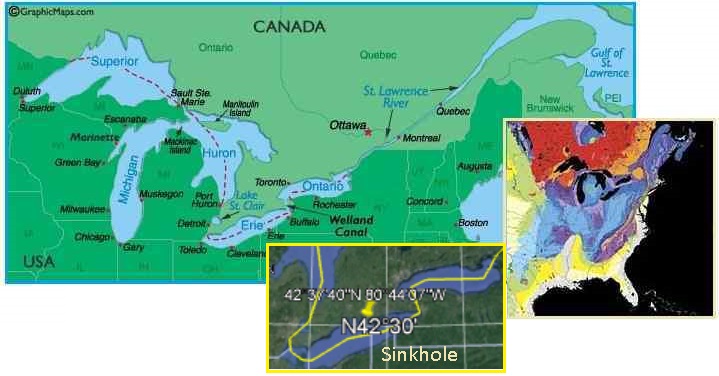
Zetatalk Confirmation
5/31/2022: The Seaway
will rip open during the Pole Shift, such that it will
become a wide bay, and to a lesser degree during the New
Madrid adjustment. The path of this Seaway expansion will run
along the rock strata that allowed the Seaway to
form in the past. This rock strata border can be seen coming
inland along the St. Lawrence River until it bridges over from
Lake Ontario to Lake Huron. Toronto is spared, being
below this path, as is Michigan. Wisconsin is protected
from the Seaway split by the volcanic Midcontinent Rift.
Thus the trauma of a Seaway
split during the New Madrid Adjustment goes inland beyond
Duluth. What can be seen from the earthquake charts and
Heliplot charts is distress within the Seaway path and above
this path in the hard rock of Canada. Despite this tugging,
Canada will not be affected by the New Madrid Adjustment that
will shatter the US in her lands below the Seaway. The Seaway
rip westward from Duluth will rumple the Black Hills of S
Dakota, but Detroit and Toronto will be unaffected though the
locks along the Seaway will be broken.
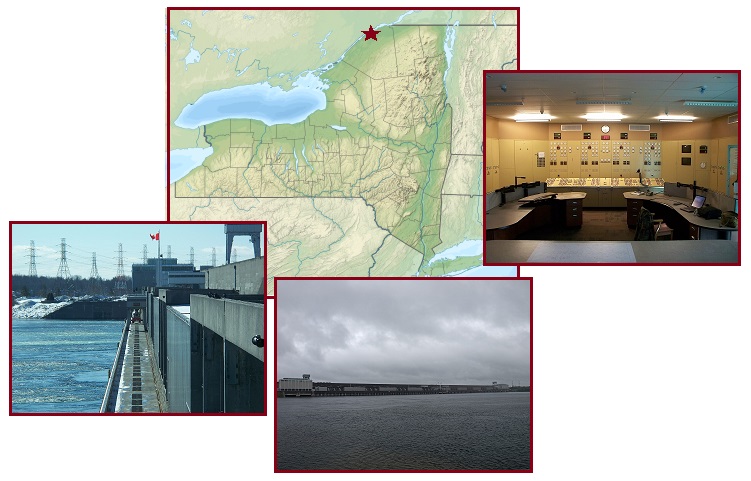
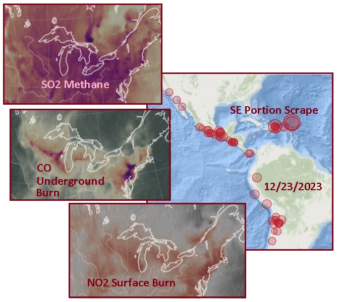
Due to the intense separation pull between the Portions along
the New Madrid Fault Line that runs to the Seaway exit, the
Seaway near Montreal has begun clapping - opening and
closing. The tugging on the Mainland Portion above the Seaway
can be seen in the burn maps as Christmas Day approaches on
December 23. The Seaway rip point ending at Detroit and into
Wisconsin can be seen. Montreal appears nervous.
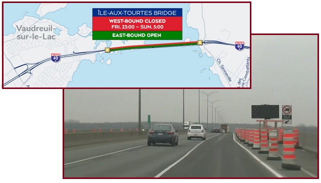
- Here are the Road Closures in and
around Montreal this Weekend
December 22, 2023
https://montreal.ctvnews.ca/here-are-the-road-closures-in-and-around-montreal
- According to Mobilité Montréal,
major roadblocks are expected to be in place this weekend,
particularly on Autoroute 40 near the Île-aux-Tourtes
Bridge.
On December 23 the rise and fall of the St Lawrence river at
Montreal was a steady rhythm, but toward the end of December 23
a change was also noted. The two Buoys along the Seaway prior to
Montreal began to show excessive high water not seen earlier nor
on any of the buoys in the Great Lakes. Is a squeeze at Montreal
in process?
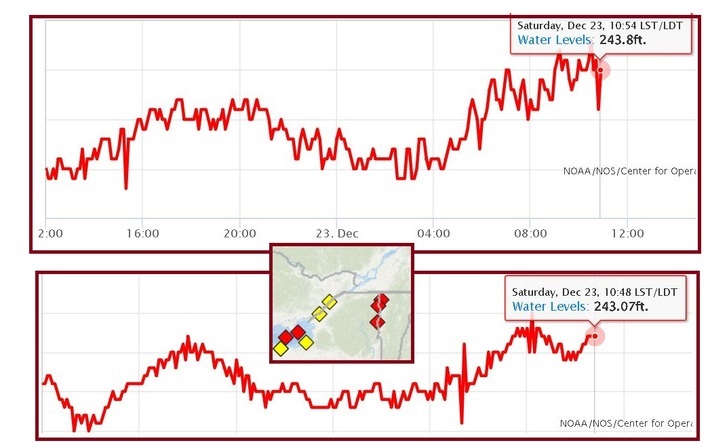
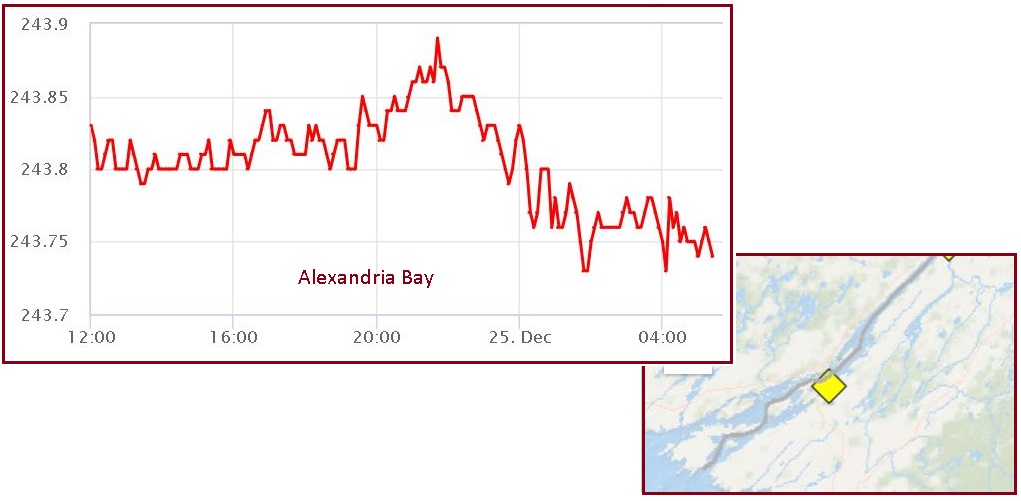
Then on December 24-25 the Montreal buoys became even more
erratic. Both the Ogdensbury and Alexandria Bay buoys along the
narrow Seaway in New York state confirm this erratic rise and
fall.
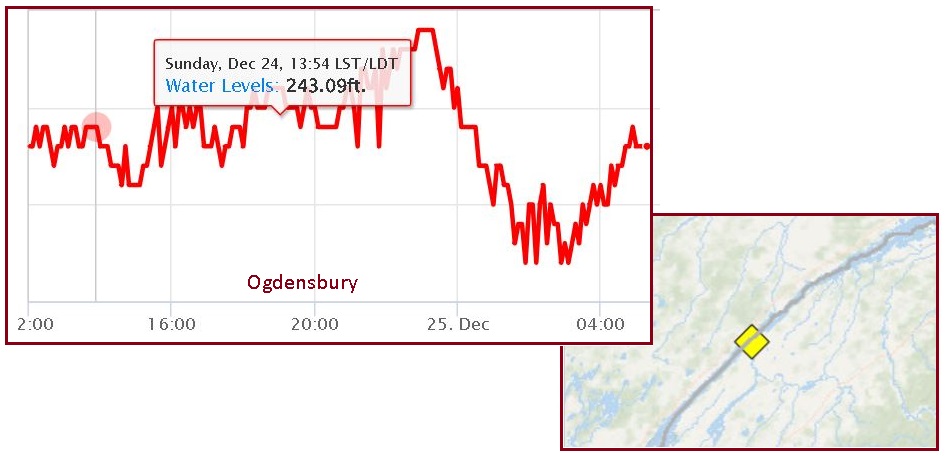
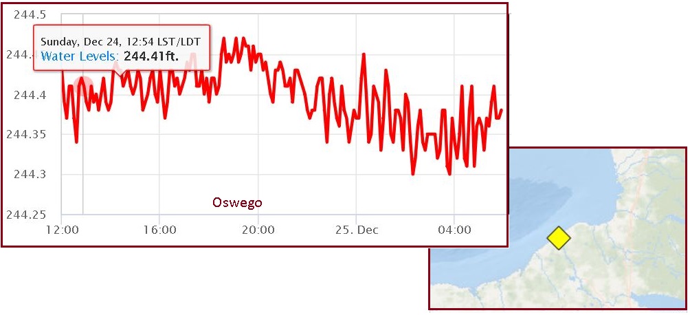
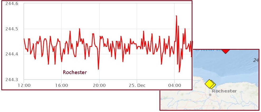
But just further inland along the shores of Lake Ontario the
buoys at Oswego and Rochester in New York State do not show this
irregular rise and fall of the waters.
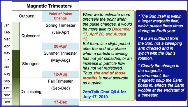
Magnetic Trimesters
At the start of the ZetaTalk Saga the Zetas described the Magnetic
Trimesters that occur in December, April and October of
each year. These periods of increased earthquake activity are
caused by magnetic throbbing outside the Earth’s Solar System,
and in 2008 NASA’s IBEX programs confirmed this throbbing and
its source – a large magnetic field in space. The Christmas
Hammer in 2007 was documented in detail showing the
increase in earthquakes during the December Trimester.
ZetaTalk Confirmation
12/20/2006: Since
magnetism is viewed as polarized, a N Pole and a S Pole, with
particles flowing from one to the other, the idea that there
would be trimesters is confusing. We have explained that the
Sun's magnetism reaches to the ends of the solar system and
beyond, and dominates. Mercury and Earth, for instance, align
with the Sun's permanent alignment, and for those who say the
Sun flops about, reversing fields every 11 years, NASA's own
Ulysses probe proved them wrong in 2001. Imagine the solar
system itself aligned along a magnetic flow line of a larger
field, which pulses. It is no accident that the Earth, a
magnetic planet, is going round the Sun every 365 days or so,
as the magnetic trimesters have something to do with this
progression.
ZetaTalk Confirmation
6/6/2004: Why
is it the Sun, as the giant magnet dominating the solar
system, points North and South with its poles in the
directions it does? For those late to this argument, the Sun
does not reverse polarity every 11 years as NASA states, and
the solar magnetic field reaches beyond the outer bounds of
the solar system, affecting all the planets. The Sun likewise
is under the dictates of influences that surround it, and as
the Sun goes, so go the planets.
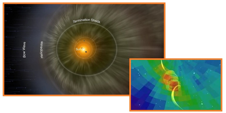
- NASA’s IBEX Observations Pin Down
Interstellar Magnetic Field
February 26, 2016
https://www.nasa.gov/missions/ibex/nasas-ibex-observations
- Now, a new study uses IBEX data
and simulations of the interstellar boundary – which lies
at the very edge of the giant magnetic bubble surrounding
our solar system called the heliosphere – to better
describe space in our galactic
neighborhood. Published Feb. 8, 2016, in The
Astrophysical Journal Letters, precisely determines the
strength and direction of the magnetic field outside the
heliosphere. Such information gives us a peek into the
magnetic forces that dominate the galaxy beyond, teaching
us more about our home in space.
But due to the pace of the New Madrid Adjustment, which was at
first slowed down by the Council of Worlds by the Humming
Boxes along fault lines and then by the Monoliths,
the Council needed to speed up again to get back on schedule.
To counter the effects of slowing down the New Madrid Rupture,
the Council imposed a Severe Wobble,
which made the Magnetic Trimesters irrelevant. The Zetas
estimate they account for 20% of the earthquake activity, with
the Severe Wobble causing the remaining 80%.
ZetaTalk Insight 7/31/2022: The
Earth is in the throes of a Severe Wobble so that delays in
the 7 of 10 Plate Movements caused in the past by
the humming boxes will be counteracted, keeping the
Pole Shift on schedule. In the past, the Council of Worlds
granted a delay in the 7 of 10 Plate Movements to allow Obama
a chance to make his planned announcement about Nibiru.
Instead, Obama lost courage and the humming boxes were removed
from plate borders and fault lines. The gradually increasing
Severe Wobble approved by the Council of Worlds in June
2021 is now having its effect.

ZetaTalk Confirmation
12/20/2023: When
Nibiru was at a distance, the Magnetic Trimesters that
affected the Earth in December, April, and August were
noticeable in increased earthquakes. But at present due to the
Severe Wobble imposed by the Council of Worlds it is hard to
discern what quake swarms are due to the Magnetic Trimester
effect and what should be ascribed to the aggressive Plate
Movement orchestrated by the Council of Worlds. Perhaps 20%
are due to the Magnetic Trimester and 80% due to manipulation
by the Council.
As we have mentioned, the
Council slowed down the pace of the 7 of 10 Plate Movements by
allowing the Humming Boxes and Monoliths to be installed. This
was to allow the Obama administration time to make the
announcement in 2015 about the presence of Nibiru. Obama
failed to do this, but the delays had an impact on the pace of
change in the Earth’s part of the Universe, and these delays
impacted the schedule for other changes elsewhere in the
Universe. Thus the Council was ordered to catch up, and they
are doing so by expediting the Plate Movements at the present
time.
The focus on the New Madrid
Rupture has shifted since 2021 from the hard rock hook under
Turkey that prevented the NE corner of the Africa Plate from
dropping, to the Toe of the Isthmus pulling away, to the SE
Portion scrape over the hump of the Caribbean Plate, to the
unzipping of the fault line up from NOLA toward the Bridge, to
the release of the Bridge itself. As of this writing Nancy is
focused on the Montreal scenario where the Seaway pulls apart
while the New Madrid Fault Line completes its separation. And
when it snaps back it opens the Azores for the tsunami threat.
The timeline is entirely in the hands of the Council of
Worlds, who can adjust any of the factors at play. Thus, we
the Zetas, cannot predict a date.
|