|
Mississippi River
Bridges
A long standing ZetaTalk prediction made in 2006 was that
bridges over the Mississippi would fail during the New Madrid
process. We did have a snap of the I-35 in Minnesota in 2007 and
a truss snap on the Memphis bridge in 2021. And now we have a
bridge down near Cairo, Illinois. This is where the Ohio River
branches off, and close to where the hard rock Bridge which the
Zetas say must snap for the New Madrid Rupture to be on its way.
Significantly, land was notably sinking in nearby Arkansas just
to the SW of Cairo on that same day, March 23.
ZetaTalk Prediction 2/10/2006: This
creates a diagonal stress on the N American continent where
New England is pulled to the east while Mexico is pulled to
the West, so the New Madrid is put under slip-slide stress
where one half, east of the Mississippi, will move toward the
NE while the other, west of the Mississippi, moves toward the
SW. A widening seaway also does not affect just those land
masses bordering the seaway, as buckling occurs inland and
afar. What does man assume caused the Black Hills to be so
rumpled, with the appearance of a recent buckling and heaving?
This is the center of a land plate! The tearing of the seaway
does not end at Duluth, Minnesota. It travels underground to S
Dakota!
ZetaTalk Prediction 8/16/2006: What
does this do to the N. American plate? It pulls it at a
diagonal, ripping the rock fingers along the New Madrid fault
such that the land to the East of the Mississippi moves up and
to the East, toward New England, and the land to the West of
the Mississippi moves down and to the West. This does more
than tear most of the bridges along the Mississippi.
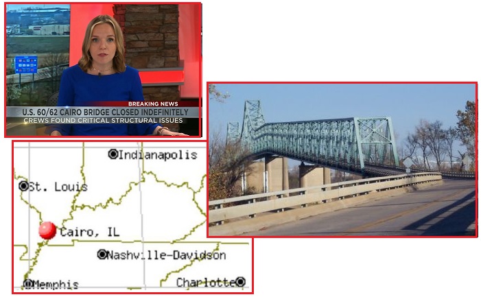
- U.S. 60/62 Mississippi River Bridge
Closed after ‘Critical Issues’ Found during Inspection
March 23, 2023
https://www.kfvs12.com/2023/03/23/us-6062-mississippi-river-bridge
- The Illinois and Missouri
Departments of Transportation announced the U.S. 60/62
bridge over the Mississippi River will be closed to all
traffic. According to a release from the Missouri
Department of Transportation, IDOT reported critical
issues were found during the routine inspection that
started on March 13. They said the bridge will stay closed
until a plan can be developed and implemented. The bridge
connects Missouri and Illinois. It’s frequently used by
farmers.
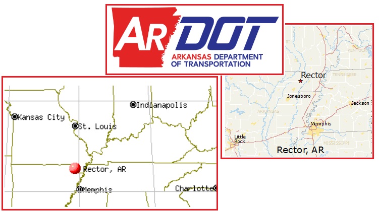
- ARDOT closes Clay County Bridge
March 23, 2023
https://www.kait8.com/2020/03/23/ardot-closes-clay-county-bridge/
- According to ARDOT, the bridge on
Highway 139 has been closed because, during a routine
inspection, they found structural deficiencies.
- Highway back Open after Emergency
Repairs
March 23, 2023
https://www.kait8.com/2023/03/23/traffic-alert-highway-closed
- A Clay County highway is back open
after crews made emergency repairs. ArDOT shut down State
Highway 139 southeast of Rector on March 23 following a
drain pipe failure and partial collapse.
On May 12, 2021 the bridge to Memphis was closed due to a
snap. The ZetaTalk conclusion was that the West side of the
Mississippi had dropped, putting stress on the truss.
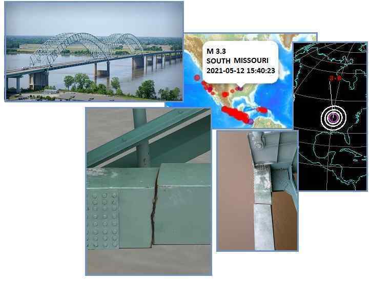
- I-40 Bridge over Mississippi River
remains Closed after Structural Crack Discovered
May 12, 2021
https://www.fox13memphis.com/news/local/heads-up-drivers-i-40
- The I-40 bridge has been shut down
indefinitely. The bridge is closed because of a structural
infrastructure crack in the bridge. The crack was found in
the “bottom side of the bridge truss” or support beam.
ZetaTalk Prediction 5/31/2021: It
is no coincidence that the I-40 was forced to close just 3
days after the Colonia Pipeline was forced to close. We
predicted that the New Madrid Fault Line would start unzipping
in the Gulf, near New Orleans, and thence proceed up the
Mississippi. The Junta closely monitors the angle of alignment
of both banks of the Mississippi to determine motion, and
noted a torque or twist. The metal and concrete in bridges and
pipelines cannot tolerate this before snapping or leaking,
thus the Colonial was closed where it crosses at Alabama. Not
3 days later the I-40 at Memphis and Arkansas was cracking.
This process will not abate.
On August 3, 2007 the I-35 bridge
over the Mississippi River to Minneapolis snapped, dramatically.
The NTSB reported that the Wisconsin side of the bridge had
shifted 50 feet to the East during the snap, showing the stress
the I-35 had been under preceding the snap. Residents
noted symptoms of Earth movement, methane smells associated with
rock layers pulling apart, algae blooms on the methane released
under water, and a vibration!
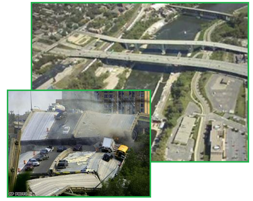
- Bridge Collapse Probe Focuses on
Unexplained Shift
August 3, 2007
http://www.cnn.com/2007/US/08/03/bridge.structure/
- Investigators trying to figure out
what caused Wednesday's massive bridge collapse are
focusing on the southern end of the span, which "behaved
differently" as it fell, the National Transportation
Safety Board said Friday. The NTSB says one part of the
bridge shifted 50 feet as it fell, while other sections
collapsed in place. What's getting investigators'
attention is the way the southern part of the bridge fell
in a video they've already examined -- recorded by a
security camera near the bridge's north end -- and the way
the section settled after the collapse. It appears that it
has shifted approximately 50 feet to the east and when we
compare that to what we've seen in the rest of the bridge
-- the rest of the bridge appears to have collapsed in
place.
ZetaTalk Explanation 8/2/2007: We
have predicted that bridges crossing the Mississippi will be
affected when the New Madrid and related fault lines adjust,
going into the pole shift. Was this bridge collapse which
crossed the Mississippi in Minnesota caused by such an
adjustment, the footings on one side of the bridge moving in
an opposite direction from the footings on the other side, or
perhaps the bridge being pulled apart? The Mississippi River
is born in Minnesota, tumbling out of the headwaters in the
highlands of Minnesota over a series of natural falls. This is
a clue that adjustments in the rock strata could be involved.
The highlands of Minnesota come to a point at Minneapolis,
with lower land lying to the East along this point. What
caused the land to the East to drop, unless this land was
stretched in the past?
We have stated that the
ripping apart of the St. Lawrence Seaway ends in the rumpled
Black Hills of SD. Run a line from Montreal, at the mouth of
the seaway, to Rapid City, SD and the line runs through
Minneapolis. Why would an adjustment be made in the middle of
this stretch zone while the seaway itself did not part? When
we described the diagonal pull the N American continent is
enduring, and just how this will snap when adjustments are
made, we did not intend that this process would occur
smoothly, all at once as described. Weak points along the rip
lines give way one by one, each such adjustment placing stress
on other points in a domino manner. The I35W bridge, being the
larger of the bridges crossing the Mississippi at this point,
was less able to adapt to a change in position vis-a-vis its
footings on either side of the river, as it was an interstate
bridge supporting several lanes, and thus had massive and thus
rigid supports. Smaller bridges have more flexibility as they
are built to withstand uneven loads on either end, thus are
more springy by design.
Will there be more such
disasters along the Mississippi and in the cities that will be
affected by the New Madrid and seaway rip? This is just the
start, and when the pace picks up, there will be no question
that something other than Global Warming is the cause.
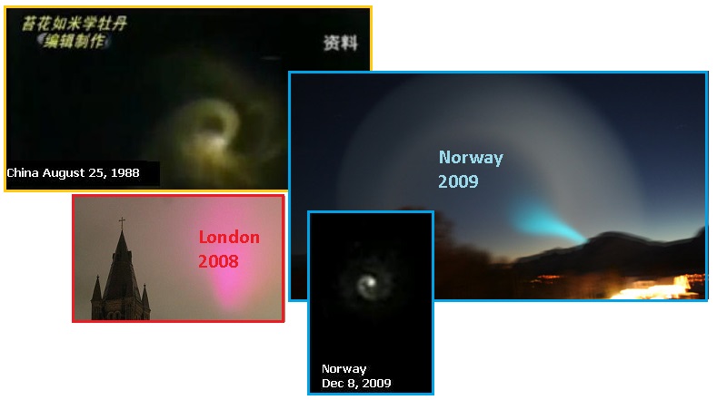
Swirl Swarms
Colorful Petrol swirls have appeared in the past. China
recorded one in 1988, and a Pink Neon Cloud in London was
captured on camera in 2008, and then of course there was the
bright blue Norway Swirl, which grounded while on camera in
2009. But the evidence of Petrol in the vast tail of Nibiru has
been on the increase, with rainbow clouds and now Petrol Swirls
worldwide.
ZetaTalk Explanation
12/8/2009: As
with all swirls that develop in nature, they start with a
small movement in one place that creates a vacuum pulling
matter behind it, and thus builds. Galaxies swirl. Water going
down a drain swirls. And these large charged atmospheric
swirls are chasing after some part of the tail waft that is
more or less charged than the surrounding atmosphere.
ZetaTalk Explanation
10/25/2008: This
has been explained away by the authorities as a reflection of
city lights on a high cloud. But don't high clouds and city
lights occur often, around the world? We have stated in the
past that occasional neon clouds or light pillars were due to
atmospheric changes from the tail of Planet X. Light pillars
were flames of gas in the atmosphere, quickly burning out.
Neon clouds are not seen at night, as they are highly
reflective of sunlight primarily during dawn or dusk. This is
not due to water vapor reflections, such as rainbows, but
other chemicals in the atmosphere. This recent pink cloud over
London was similar to a neon cloud, but was reflecting the
lights from the city, as explained in the article. However,
this would not be occurring without chemicals from
the tail of Planet X mixing into the atmosphere. Such displays
will become more common.
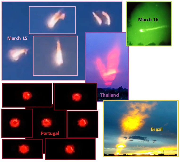
- March 15, 2023 Portual
https://t.me/ZetaTalk_Followers/28449
- Hello, I need your help, what is
this? Appeared in the skies of Portugal, thank you very
much.
- March 6, 2023 Thailand
https://www.facebook.com/photo/?fbid=10162905195853973
- Spinning burning Petrol. Strange
sky observed during yesterday's sunset in Thailand.
- March 16, 2023 Russia
https://t.me/ZetaTalk_Followers/28580
- Looks like Spiral or burning
Petrol captured on night-vision.
- March 15, 2023 Florida
https://t.me/ZetaTalk_Followers/28487
- Biblical Fire in the Sky,
petro-chemical elements from the tail of Nibiru entered
Earth's atmosphere and caught fire! Much more headed our
way!
- March 3, 2023 Brazil
https://twitter.com/ZT_Followers/status/1636387283598467072
- Clouds on fire caused by Nibiru
petrol elements. More on the way!
ZetaTalk Comment
3/31/2023: Burning
Petrol has been on display for several years, usually above
the clouds where it is set alit by lightning. Neon clouds are
also a chemical reaction within the air caused by the Petrol.
Dramatic spinning Petrol masses, alit, have been seen since
the blue Norway swirl in
2009. They are now on the increase. Hurricanes are
swirls that encompass large areas. Will the Petrol swirls,
powered by heat during burning, develop to that size? This is
possible and likely. But petrol burns tend to dissipate into
smoke, regardless of size.
Another sign that Nibiru is a real and present danger and that
the New Madrid Fault Line separation through the Gulf of Mexico
is not your imagination is the Red Tide swamping Florida along
its West Coast.
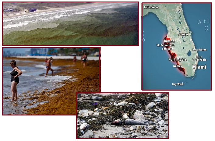
- Gigantic 5,000-Mile Blanket of Rotting
Seaweed Dubbed the 'Red Tide' Invades the Coast of Florida
March 13, 2023
https://www.dailymail.co.uk/news/article-11852089/Gigantic-5-000-mile
- Florida's southwest coast is
experiencing a flare-up of the toxic red tide algae
setting off concerns that it could continue to stick
around for a while. The current bloom started in October.
Red tide, a toxic algae bloom that occurs naturally in the
Gulf of Mexico, is worsened by the presence of nutrients
such as nitrogen in the water. High levels of
sargassum in coastal waters have been observed in recent
years.
ZetaTalk Comment
3/31/2023: Given
the activity in the Gulf of Mexico during the setup for the
New Madrid Rupture, it is not surprising that an algae bloom
would develop. The separation of N America into the SE and
Mainland Portions tears rock which releases
Methane from trapped vegetation in the rock layers being
ripped apart. And when this happens under the waters of the
Gulf this results in an algae bloom. Within the past few years
the Sargassum bloom also
arrived in the Gulf, due to the Red Dust from Nibiru’s tail
which provided the iron needed for a Sargassum resurgence.
The surge in Sargassum in 2019 allowed the Humpback whale to
make a comeback. What does this have to do with Nibiru, a proof
of Nibiru? The red dust in the tail of Nibiru allowed the
Sargassum to bloom. A long standing ZetaTalk prediction was that
the Oceans will be lush. The red
dust allowed the Sargassum to bloom, which the Krill eat, which
the Humpback whales eat, and thus they all made a comeback.
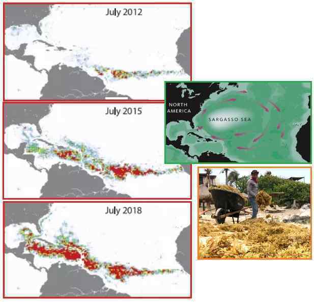
ZetaTalk Comment
7/31/2019: The
Sargassum bloom is most intense in the Caribbean, in the Gulf
of Mexico, where the red dust in the water cannot readily
disburse because the Coriolis Effect must work
within the circle of Caribbean Islands. The currents that
circle the Sargasso Sea also pull this red dust back to the
coast of S America. There will be many more such sea blooms
around the world, which the establishment will struggle to
explain.
Mainland Drop
Meanwhile the Mainland Portion continues to drop. Day after day
some spot on the Mainland turns solid black on the Heliplots,
while around the world no others are turning black. Yet huge
quakes do not happen to accompany these black Heliplots in the
Mainland. See the evidence at the bottom of this Newsletter as
presented on the JOLT
Timeline Blog on the Pole Shift ning. How could it be that
the Mainland has black Heliplots with no other signs of action
besides train derailments, building collapses, sinkholes opening
up, and breaking water mains? This is a silent stretch. Since we
last reported in this newsletter about the New Madrid process on
March 19, there was a significant quake on the N Andes Platelet
– caused by the Mainland Portion drop.
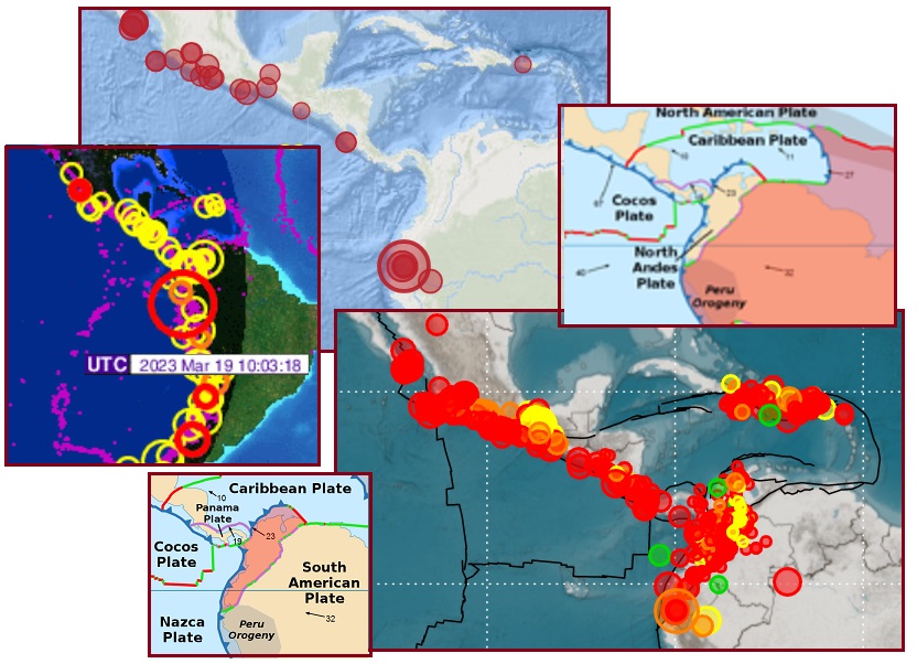
ZetaTalk Explanation
3/19/2023: The
March 19 quake on the North Andes platelet is at the point
where a portion of the Nazca Plate is set to snap off. There
is plate fracturing at this location and along the Andes
due to past S America Rolls and New Madrid Ruptures. The
Mainland Portion is dropping on the Cocos Plate. The Caribbean
Plate is being pulled westward by its attachment to the S
America Plate, so this is yet another push against the Cocos
Plate. The Cocos is loath to fracture so pushes as a unit on
the Nazca Plate which is held by a rock hook to the Panama
Plate. This rock hook has now snapped to form a new platelet.
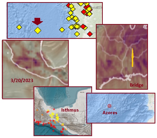
On March 20 we continue to see the Mainland drop, shoving
westward against the Juan de Fuca Plate. The start of the
New Madrid Fault Line at the Isthmus continues to pull apart
into the SE Portion and Mainland Portions, with deep quakes at
the Isthmus. The path to the Bridge appears separated into the
Portions, clear on the SO2 maps, with only Southern Indiana
showing distress and tearing. And today, the cherry on the top
of this mess, is a quake right at the Triplate Junction at the
Azores.
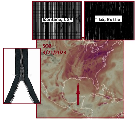
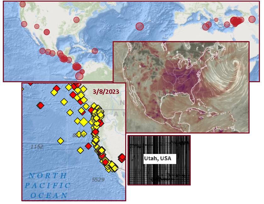
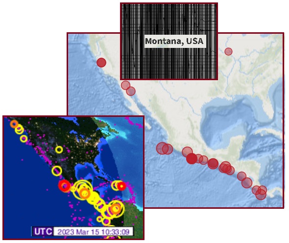
On March 21 we see that the unzipping up the Mississippi River
has traveled all the way to the Bridge. No more SO2 ripping of
rock, on most days. The Isthmus also shows this pale SO2
signature, indicating separated Portions. This means the
pressure is really on the Bridge, like a zipper that is stuck,
the sides of a jacket would be pulled to the right and left
during this process of trying to get the Zipper to move.
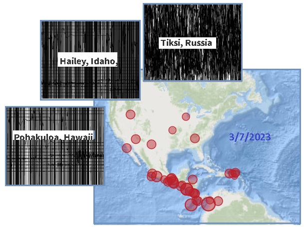
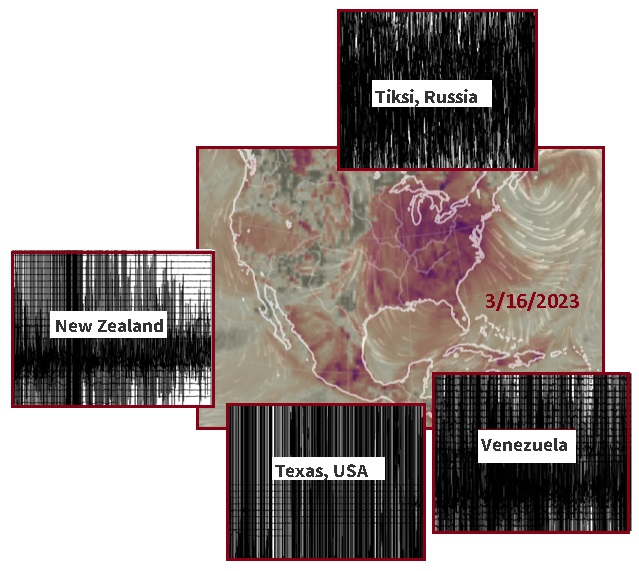
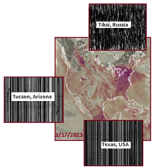
Significantly, only Montana and Tiksi on the Arctic border are
black on the Heliplots this day.
For those who doubt that the SE Portion is being ripped apart
while being held between the Mainland of N America and its
connection to the Africa Plate, just check out the CO and SO2
record for New York City and New Jersey on March 22. Red hot. As
we know Methane kills birds and fish, and SO2 accompanies
Methane. CO is lack of Oxygen, a killer. Thus the die-off of
Dolphins and Whales along New Jersey beaches. Yes, NYC is
becoming destabilized by rock movement too.
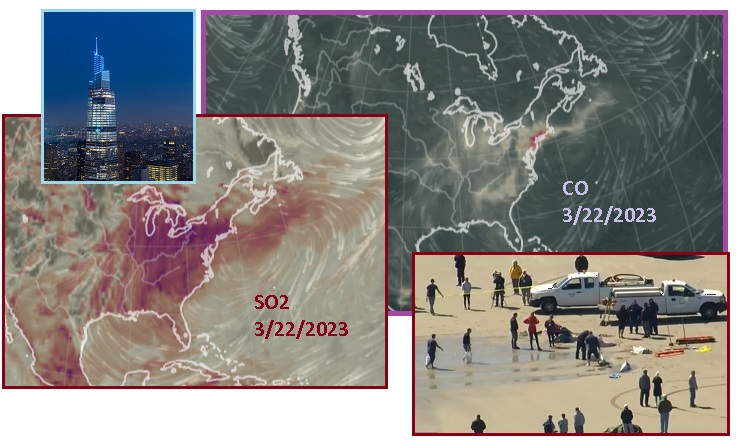
- 'Elevator Malfunction during
Maintenance' caused NYC's New $3.3BN One Vanderbilt
Skyscraper to Shake
March 22, 2023
https://www.dailymail.co.uk/news/article-11887385/NYCs-new-One-Vanderbilt
- Terrified workers fled a new
Manhattan skyscraper after experiencing a huge 'shake' run
through the building, after workers at the popular
business and tourist site were repairing one of the
elevators and, according to the managers, caused the
shaking.
- Eight Dolphins Die after 'Mass
Stranding' on New Jersey Beach - as the String of Mysterious
Sea-Life Deaths across the East Coast Escalates
March 22, 2023
https://www.dailymail.co.uk/news/article-11887465/Eight-dolphins
- The remaining six dolphins were
euthanized several hours later, adding to the more than
three dozen cetaceans that have washed up dead in recent
months.
Here is the record of Mainland Heliplots turning black, while
no others around the world did - the silent stretch leading to
#5 on the Jolt
Timeline.
|