|
Pemex Explosion and
Tehuantepec Ridge
The Addendum is being published early on January 21 (3 weeks
after the end of 2021) to show the status of the New Madrid
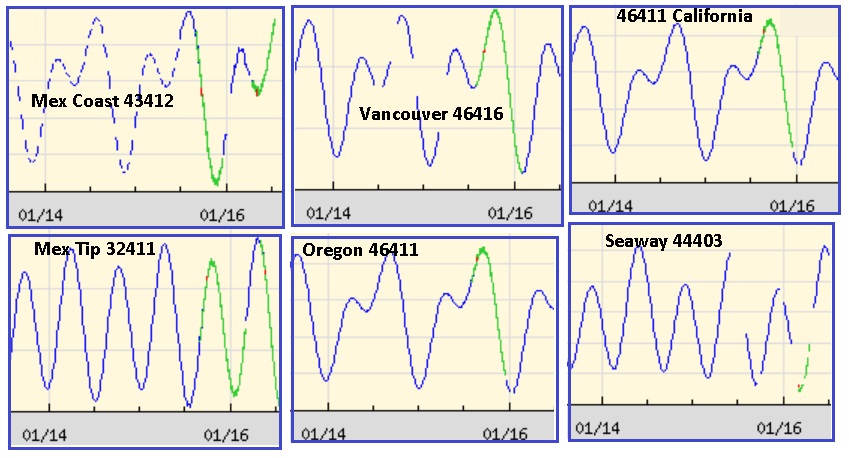
rupture. We are on the verge. After the great Pacific buoy alert
on January 14, the buoys lingered on alert for a couple days
through January 16. These buoy alerts did not rise from the
Tonga volcano eruption, but rather at the top of the Pacific.
Tonga was a reaction to Pacific plates compressing and
overlapping, not a cause of the buoy alerts, though the media
refuses to clarify that. UFO displays were seen in S Carolina
and Ireland on January 16, warning of pending tsunami.

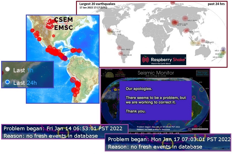
The USGS has stopped reporting quakes on January 17, for the
second time in a week. The last time was just a day or so ahead
of the big Pacific buoy affair, which started up at the top of
the Pacific and later was blamed on Tonga which is on the bottom
of the Pacific. Why do they keep taking quake reports offline?
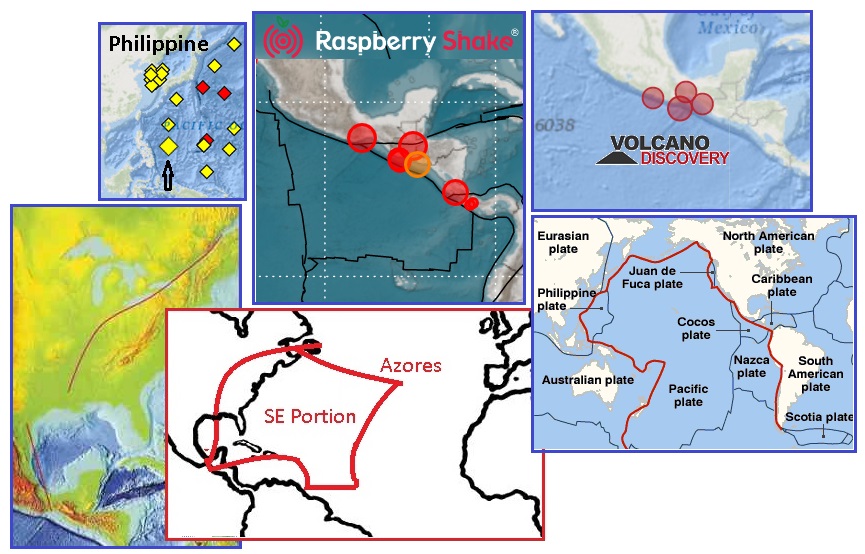
Other sites like Raspberry Shake and Volcano Discovery keep
reporting without problems. The Zetas explain.
ZetaTalk Explanation
1/17/2022: The
USGS has been in coverup mode
for almost two decades. At first they just reduced the
magnitude of all quakes, and ordered the rest of the world to
go along with their dictates. They regularly drop
quakes that occur in unpopulated area or under the water
at sea. This is why other quake reporting sites have so many
more quakes to report. But the USGS
soldiers on, regularly reducing the magnitude of quakes.
At present the quakes they do report have been reduced by an
estimated 4 magnitudes.
Why are they now taking their
quake reporting site offline, stating "no fresh events in
database"? This situation also occurred the day before
the Pacific buoys went on alert on January 14. Was the USGS
aware that the Pacific was going to compress? They are hyper
aware and before a massive quake swarm that would alarm the
public can occur, are set to take their public website
offline. This is part of the Nibiru coverup, but hopefully
this will change after the public becomes aware that Nibiru is
real and set for a passage.
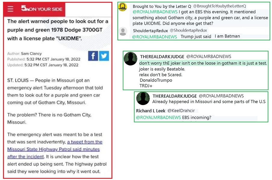
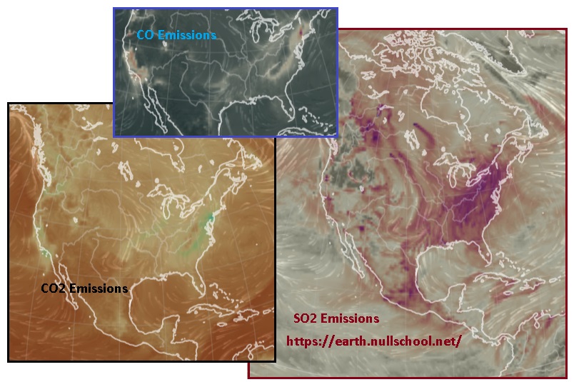
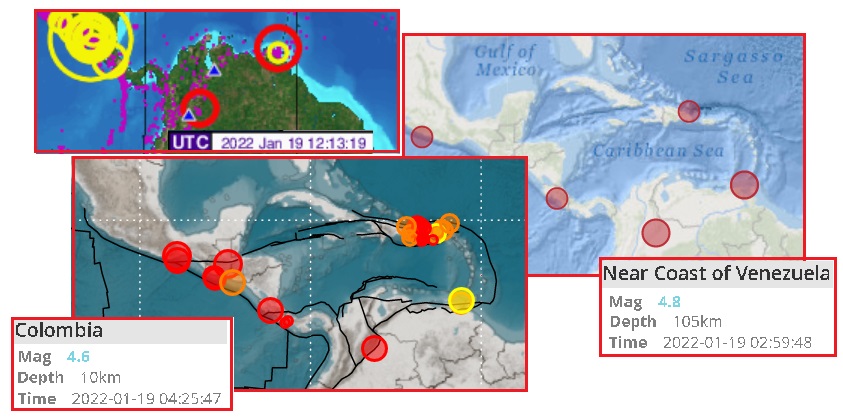
On January 18 the EBS system was being tested in Texas and
Missouri. By January 19 emissions from tension in the rock of
the N America Plate was extreme. A NOAA map of SO2, CO, and CO2
show both the SE Portion and Mainland Portion awash with these
emissions. This stress goes all the way to the tip of Mexico. On
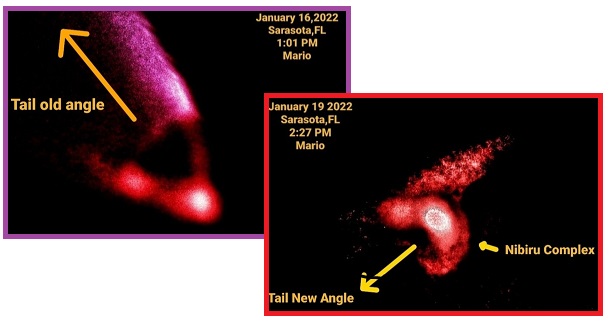
January 19 Mario of the ZetaTalk Followers group noted that the
tail of Nibiru had changed direction, from pointing to the left
to pointing to the right. This is suspected of being a Council
of Worlds maneuver inciting a Severe Wobble to break the coverup
over Nibiru.
What would cause the Mainland Portion of N America to start to
slide to the SW? And why is the tip of Mexico associated with
the start of the New Madrid unzipping? It appears that the
Philippine Plate, which had 3% yet to go on the last 7 of 10
analysis, is now active. Is the fact that it is directly across
the Pacific from the tip of Mexico significant? Looking at what
might be blocking the Mainland Portion from sliding to the SW,
it appears the Cocos Plate would have to fracture. The Zetas
comment.
ZetaTalk Explanation
1/18/2022: We,
the Zetas, have given many details about the New Madrid
unzipping process. We have stated that the tip of Mexico
should be closely watched, as quakes there would signal the
start. We have stated that the Mainland Portion of the N
American Continent will slide to the SW while the SE Portion
of the Continent will seem to rise toward the NE. We have
stated that the N American Continent has been under a bow
stress, with the Aleutian Islands being pulled toward the tip
of Mexico. And we have stated that the New Madrid unzipping
would come up from the Gulf, then up the Mississippi River and
along the fault line under the Seaway.
In all of this, we have not
detailed what the trigger event would be that would start the
unzipping. Since we have stated that the unzipping is to occur
during a 3 week period to start before the end of 2021 and
complete in 2022, there is no reason for secrecy. We are at
the brink. Obviously, if the bulk of Mexico is included in the
Mainland Portion, and Mexico is blocked from a slide into the
Pacific by the Cocos Plate, and the tip of Mexico is covered
in quakes while this portion of the Mainland is repeatedly
slammed against the Cocos Plate, then this is a factor.
The Caribbean Plate is being
driven westward by the S American Roll, but the Caribbean
Plate is entangled with the S America Plate and hugged by the
SE Portion of the N American Plate. All these as a unit refuse
to move into the Pacific. But the void formed by the
compressing Pacific is pulling the Mainland Portion of N
America westward. This void was increased just days ago during
the great Pacific compression of January 14-15. The void in
the Pacific just west of the Cocos Plate is also increasing
when the Philippine Plate completes its tilt as it has for
some days now.
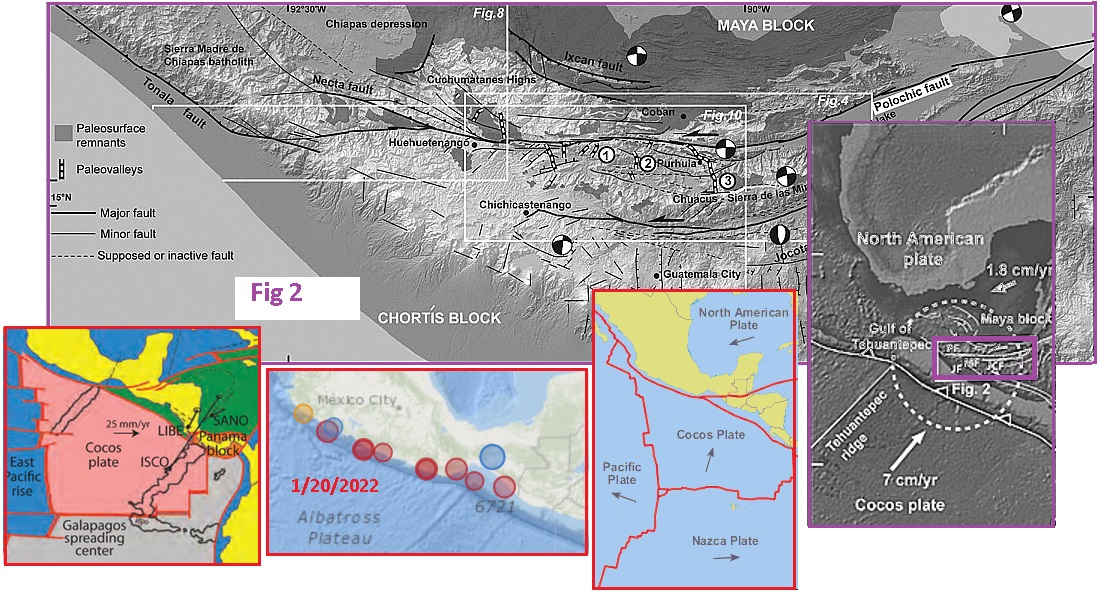
The trigger event for the New
Madrid unzipping will thus be a movement of the Cocos Plate to
the west. The Cocos and Nazca Plates are already fracturing at
Central America and will fracture further. Once the tip of
Mexico is freed and no longer blocked from a slide to the SW
the entire Mainland Portion can participate. The pressure from
a bow wanting to straighten out will have an outlet. The
release in the bow will first occur at the Mexico end of the
New Madrid Fault line. Up through the Pemex gas fields,
through the Gulf, up the Mississippi River and under the
Seaway, in that order. A diagonal rip along the New Madrid
Fault Line.
A close
examination of the Cocos Plate finds there is a fracture
point, just where the constant
quakes on the tip of Mexico are occurring. The S American
Roll is attempting to complete and pushing the Caribbean Plate
to the West. This hammering puts pressure on the Cocos Plate
too.
- Tehuantepec Ridge
https://en.wikipedia.org/wiki/Tehuantepec_Ridge
- The Tehuantepec Ridge is a linear
undersea ridge located off the west coast of Mexico in the
Pacific Ocean. It is the remnant of an old fracture zone.
It lies within the tectonic Cocos Plate, separating the
lower and older seafloor of the Guatemala Basin which lies
southeast of the ridge from higher and younger seafloor
which lies to its northwest.
ZetaTalk Explanation
1/20/2022: The
Point where the Caribbean and N American and Cocos Plates
touch is a weak point where fractures have occurred in the
past. It is just below the Pemex gas fields, a known weak
point in the Gulf of Mexico along the start of the New Madrid
Fault Line. The tip of Mexico is riddled with fault lines at
this triple juncture as a result of past fractures. The border
between the N American Plate and the Cocos Plate at this
triple juncture is riddled with earthquakes lately, on January
20 the Volcano Discovery website showing over a dozen above
Magnitude 3.
Since Mexico must slide to the
SW to allow the Mainland Portion of the N America Plate to
slide to the SW, the Cocos Plate must move out of the way. As
noted on the Cocos Plate maps, the Tehuantepec
Ridge is considered an old fracture zone, separating portions
of the Cocos Plate. The Tehuantepec Ridge springs from
the triple juncture, and if it were to fracture again would
open a pathway for the N American Plate to slide to the SW.
This is indeed the process in place on this day, during the
odyssey of the New Madrid rupture.
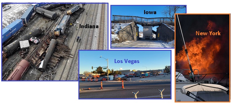
Meanwhile the tension in the Mainland Portion of N America was
causing train
derailments in Indiana on January 18 and in
Iowa and another in
Indiana on January 20. Bridges also were collapsing by
January 20 in
Iowa and Las Vegas
and explosions caused by gas line fittings in
New York and Detroit
and Oklahoma.
On January 19 the Pemex gas fields exploded. This was a key
indicator for Wave#1 and Wave#2 of the New Madrid pre-rupture
waves in 2021, as the New Madrid Fault Line starts at that
location. The quakes along the tip of Mexico, just above the
Cocos fracture point had gotten extreme, as Volcano Discovery
shows upon a search for January 20.
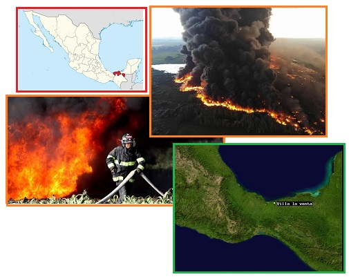
- An Explosion wasr Recorded in a Pemex
Pipeline in Huimanguillo, Tabasco
January 20, 2022
https://www.paudal.com/2022/01/20/an-explosion-was-recorded-in-a-pemex-pipeline
- This January 19, 2022, around 4:00
p.m. an explosion was recorded in a Petroleos Mexicanos
(Pemex) pipeline in La Venta, in the municipality of
Huimanguillo, in the state Tabasco Federation. According
to the first versions, the fire would have started due to
an alleged burning of grassland by the inhabitants of the
region, who are dedicated to agriculture; however, the
fire reached an active line of the Mexican parastatal,
which already had leak reports for a few weeks.
- Huimanguillo: Pemex Pipeline Explodes
in Tabasco
January 20, 2022
https://www.paudal.com/2022/01/20/huimanguillo-pemex-pipeline-explodes-in-tabasco/
- Personnel from Petroleos Mexicanos
(Pemex) and Civil Protection from Tabasco and Huimanguillo
fight this fire caused by the explosion of a six-inch oil
pipeline in Villa La Venta, local media report. The fire
started around 4:00 p.m.in the Ejido Jose Narciso Rovirosa
on a branch of Pemex pipelines that leads to the La Venta
Gas Processing Complex.
|