|
Wave#2 Slow Mo
The Zetas have recently stated that the big New Madrid rupture
can be expected by the end of 2021 or very early in 2022. They
stated that preliminary ruptures would occur in waves, coming up
from the Gulf. They stated that these waves would come
up from Mexico where the New Madrid Fault Line starts.
Wave#1 emerged in early May when the Colonial
Pipeline was suddenly closed and the I-40 bridge into
Memphis snapped a truss. Those watching the New Madrid have been
anticipating Wave#2, which seemed to
be occurring in slow motion, having started in late August.
ZetaTalk Prediction
5/31/2021: The
New Madrid will start unzipping at the Gulf, then up the
Mississippi River. Then following this first wave, another. A
second wave will proceed up from the Gulf, this time tearing
some bridges. This will be an iterative pattern.
ZetaTalk Prediction
7/31/2021: If
one examines the subterranean relief map of the Gulf one can
envision the next step as the N American Continent is torn
apart. The Yucatan Peninsula will side with the Caribbean
Plate and Florida and Alabama. Solid rock all around. There is
a ridge under the Gulf, with the deepest parts of the Gulf on
either side of this ridge. Note that the Mexican fault line
running up from Mexico City has a nexus at the Ku Maloob Zaap
pipelines. The N American Continent is being torn apart there,
parts going East, and parts going West.
ZetaTalk Prediction
8/31/2021: This
massive quake south of Alaska and on the border of the N
American Plate carries great meaning. The buoys were set to
throbbing and bobbing. What does this adjustment mean for the
pending New Madrid Adjustment that we have predicted to occur
by the end of 2021 or shortly thereafter in early 2022?
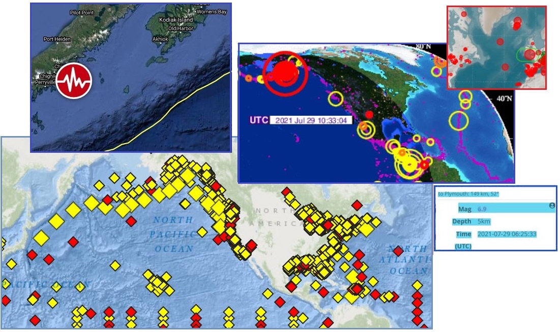
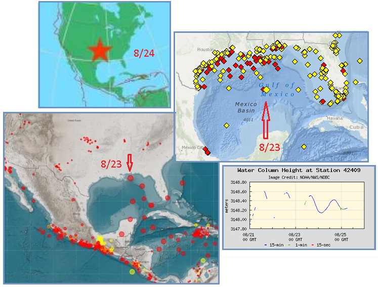
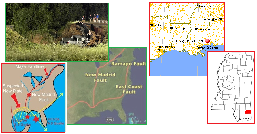
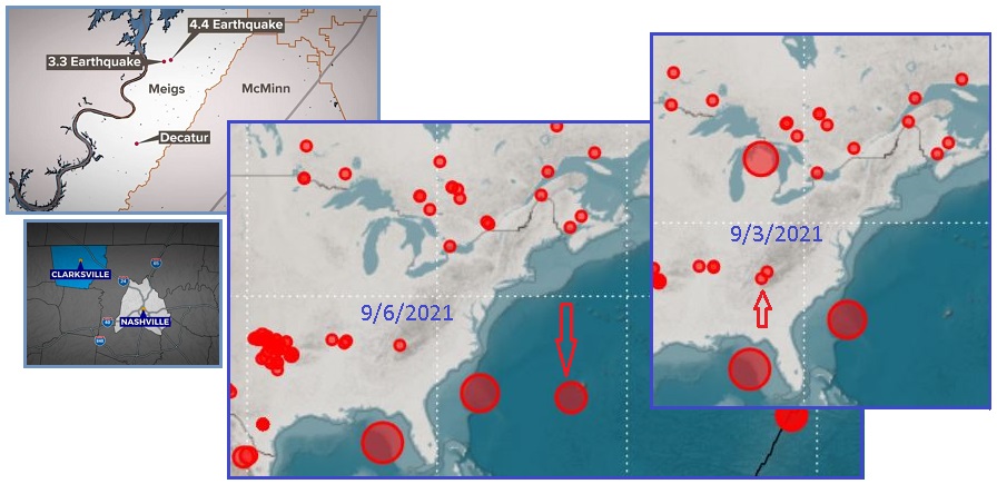
Wave#2 cleared its throat on August 19 to cause a train
derailment in the Wabash Seismic Zone in southern Indiana where
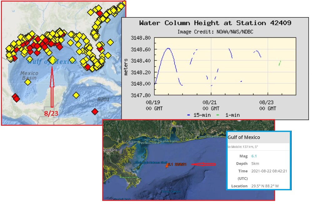
the New Madrid Fault Line passes through. Then on August 22
there was activity up from the start of the Fault Line at the
tip of Mexico. Another Pemex gas field explosion, accompanied by
seemingly endless quake swarms at the tip of Mexico. On August
23 a buoy over the deep Gulf waters above the Yucatan Peninsula
throbbed for days, the Raspberry EQ site reported a magnitude
6.1 quake at New Orleans, and a sympathetic train derailment
occurred along the Fault Line in W Virginia.
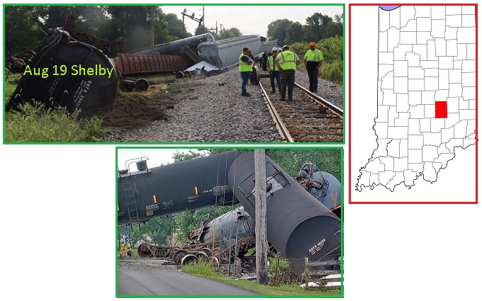
- Several Detours in Place in Shelby
County after a Train Derailed near Fountaintown
August 19, 2021
https://fox59.com/news/crews-respond-to-train-derailment-in-shelby-county/
- Nothing was harmed except for the
track itself. CSX says the impact of the crash pushed 100
feet of rails off the ground.
- Train Derailment
August 23, 2021
https://www.theintermountain.com/news/local-news/2021/08/train-derailment/
- An excursion train carrying 99
passengers and seven crew members derailed in Bemis in
Randolph County. Responding to the scene in addition to
the Sheriff's Office were the Randolph County EMS and
several local fire departments, including the Harman,
Beverly and Elkins departments.
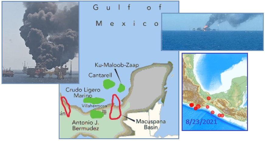
- Fire Erupts at Pemex Platform in Gulf
of Mexico, Injuring Five
August 22, 2021
https://www.reuters.com/business/energy/fire-erupts-pemex-platform
- A fire broke out at an offshore
platform in the southern Gulf of Mexico run by Petroleos
Mexicanos (Pemex), injuring at least five people. The
blaze, which occurred at the E-Ku-A2 platform at Pemex's
Ku-Maloob-Zaap oil field in the Bay of Campeche, was
brought under control around 4.30 p.m.
- A Pemex Marine Platform Burns Down in
the Gulf of Mexico
August 22, 2021
https://marketresearchtelecast.com/a-pemex-marine-platform-burns-down
- According to reports, the fire
apparently occurred in front of the Mexican state of
Campeche (Yucatan Peninsula), precisely on the Ku-Alfa
platform that is part of its largest producer complex. The
fire started after an explosion which occurred in a gas
and crude distribution center, destined for other oil
installations.
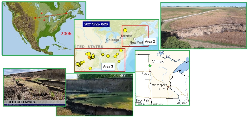
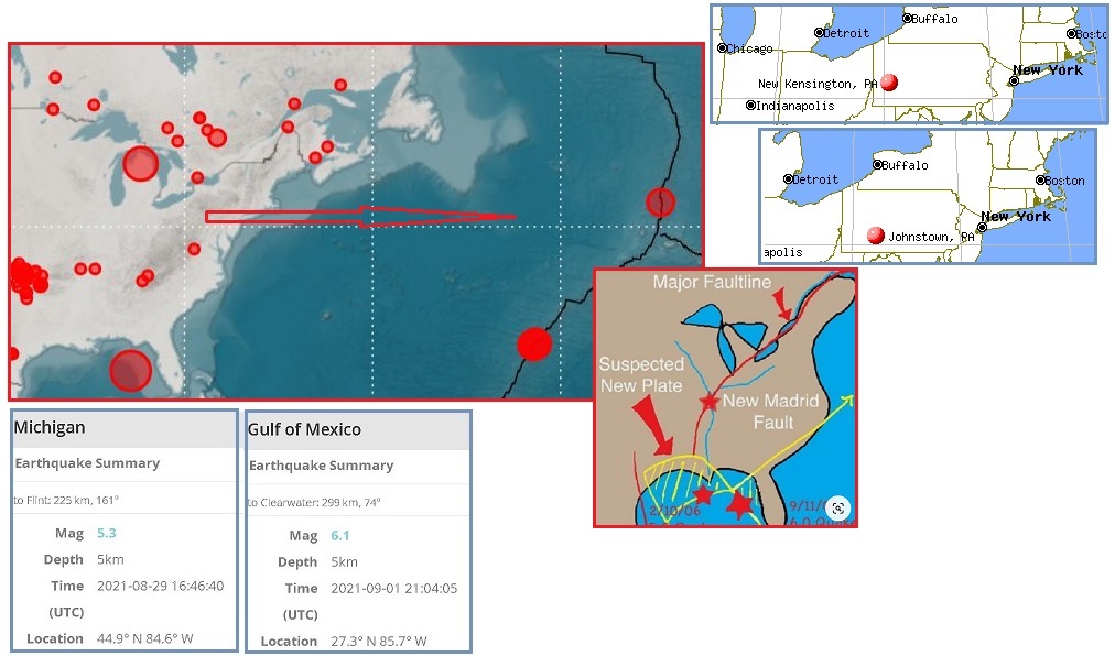
The Gulf buoy was still throbbing on August 25 when Wave#2
traveled up the Mississippi River to destabilize Oklahoma on the
West side of the Fault Line. The Oklahoma quakes registered for
almost a week. Then Wave#2 traveled all the way up the
Mississippi to destabilize the Seaway, where numerous quakes had
been popping off. This resulted in the expanding Seaway pulling
open the rip point at the end of Lake Superior. A bean field inexplicably
tore open there on August 26, puzzling experts. These New
Madrid waves do indeed outline the entire vulnerable SE Portion
of the US, where the grip is weakening.
- Bean Field Collapses in Northwestern
Minnesota
August 26, 2021
https://www.mprnews.org/story/2021/08/26/bean-field-collapses
- Some consider it a geological
wonder. A crack in the soil of a bean field in
northwestern Minnesota has caused the ground to collapse
25 feet, creating a quarter-mile-long ravine.
- It looks like the Grand Canyon! Bean
Field Collapses and falls 25 Feet Overnight in Rural
Minnesota, Baffling Farmers and Experts
August 28, 2021
https://strangesounds.org/2021/08/bean-field-collapses-minnesota
- Consequence of the extreme drought
in Near Climax, Minnesota, a small crack in the ground has
grown, causing a quarter-mile long stretch of bean field
to fall 25 feet. Few have ever seen anything like it.
ZetaTalk Insight
8/31/2021: From
the start of the ZetaTalk saga we have warned that the St.
Lawrence Seaway would split further open. We warned that
this would happen during the Pole Shift, but will be in
process well ahead of that time. In 2006 when a pipeline
carrying oil from Saskatchewan to
Chicago ruptured, we explained that this was due to the
Seaway expanding underground, all the way from the Seaway exit
into the Atlantic to the rumpled Black
Hills of S Dakota.
The N American Plate is under
extreme stress at present, locked in place at its flat top in
the Arctic while the tip of Mexico is pulled toward the West.
While the SE Portion of the N American Plate holds tight and
refuses to rip from its moorings along the Mississippi River,
the tugging on the rock strata finds other weak spots to
relieve the tension. It is notable that our suggestion that a
line drawn from the Seaway exit to the Black Hills would show
the line of tension, and Climax, Minnesota is right on that
line.
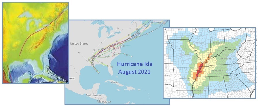
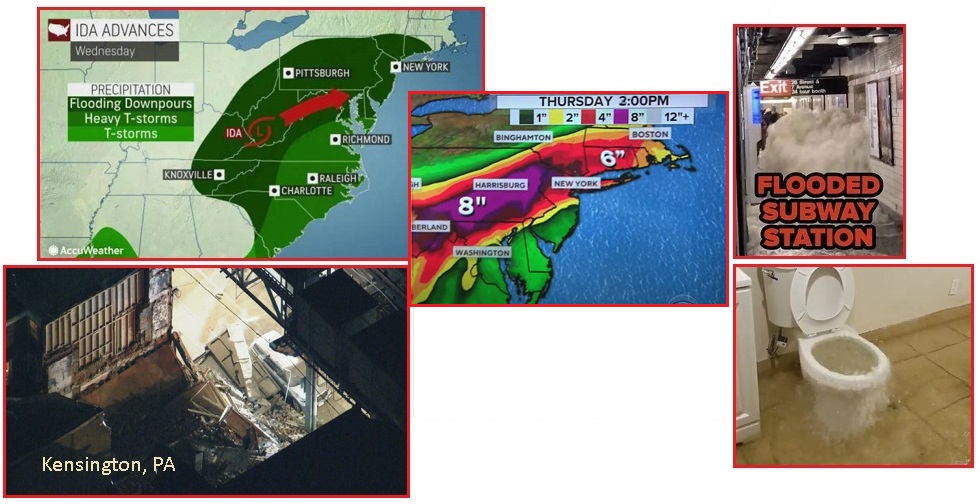
Hurricane Ida slammed New Orleans and roared up the Mississippi
in the midst of Wave#2, disguising some Wave#2 Fault Line
twitches. Ida and the Fault Line literally overlaid one another.
On August 29 it was reported that the Mississippi
ran backwards, which happened during the New Madrid
adjustment in 1811 but does not happen during hurricanes. Thus
this heaving land is a Wave#2 incident.
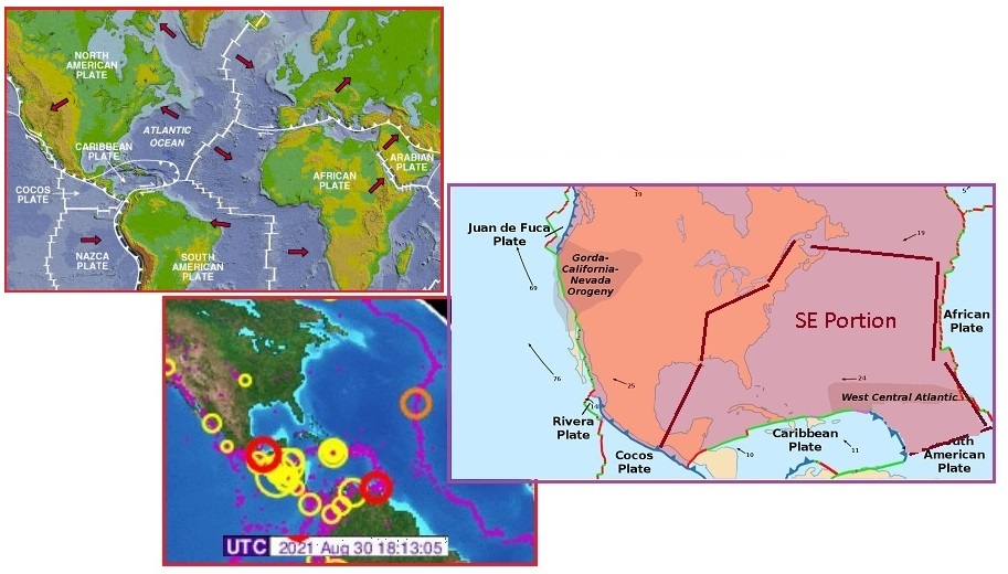
On August 30 one can see the stress tugging on the SE Portion,
which not only includes the entire SE of the US but reaches
across from the Seaway exit all the way to the Azores and down
to include the SE portion of the N American Plate at Venezuela
and Trinidad. The lower part of the Gulf of Mexico is included
in this SE Portion, reaching past the Pemex disasters to the tip
of Mexico.
On August 31 a Mississippi highway collapsed, dropping a large
portion that crossed the highway by dozens of feet. This was
blamed on Hurricane Ida, but how could blowing winds affect the
land in that manner? There was no flooding evident. Note that
the New Madrid Fault Line splinters in several directions just
above New Orleans, branching off to the East to run up the East
Coast Fault Line, and branching off to the West also. Thus for
there to be a Fault Line tug in George County, Mississippi where
the emergence of the East Coast Fault Line begins, makes this
highway collapse a Wave#2 incident.
- 2 Dead, up to 10 Injured in
Mississippi Highway Collapse
August 31, 2021
https://www.wdsu.com/article/highway-collapse-mississippi
- The Mississippi Highway Patrol,
emergency personal and rescue teams were called to a
roadway collapse on Highway 26 in George County. The
collapse is around 50 to 60 feet in length and 20 to 30
feet deep. Seven vehicles were involved in the incident.
- Mississippi Highway Collapses 30 Feet
Deep Killing 2 and Injuring 10
August 31, 2021
https://strangesounds.org/2021/08/mississippi-highway-collapse
- The hole is around 50 to 60 feet
long and 20 to 30 feet deep. Seven vehicles were involved,
including a motorcycle. A crane was brought in to lift
them out of the hole.
Then as Ida blew East through Pennsylvania and New York State,
massive flooding occurred. But was this all due to Ida? The
RaspberryShake earthquake site showed the tugging on the SE
Portion. Quakes above the Seaway show the Seaway is being pulled
apart, and a simultaneous quake in the Michigan thumb and West
Coast of Florida directly below show the SE Portion itself is
being stretched and pulled toward the Azores. Thus, compressed
rock affected drainage, and Pennsylvania dams failed while
New York
City flooded. These can be disguised Wave#2 incidents, as
the collapsed buildings in Kensington, PA show.
- Heavy Rain Prompts Evacuation below
Johnstown Area Dam
https://www.washingtonpost.com/national/heavy-rains-prompt-evacuation
- Cambria County emergency
management director and 911 center head Art Martynuska
said the water level at the Wilmore dam reached the height
that required evacuation. The Hinckston Run Dam was also
being monitored and may require evacuation. The dam is
performing as intended - water is flowing into the
emergency spillway, which helps to prevent further
degradation of the structure. However, the emergency plan
for the Wilmore Dam calls for downstream evacuations when
water flows into the spillway.
- 2 People Injured in Kensington
Building Collapse
September 3, 2021
https://philadelphia.cbslocal.com/2021/09/03/2-people-injured-in-kensington
- Two people are lucky to be alive
after a building collapsed in Philadelphia's Kensington
neighborhood. The Department of Licenses and Inspections
says a total of four buildings collapsed or were damaged.
Officials will return to the scene Friday for emergency
demolition.
The issue of land pulled taut - pulled down so drainage is
affected - arose again when the Mediterranean
side of Spain was affected by flooding. The Zetas
predicted that during the African Roll, the African Plate will
shift 125 miles to the SE along the Mediterranean at
Gibraltar. Gibraltar has been getting a spate of quakes at
the same time Spain flooding occurred. The African Roll and the
New Madrid adjustment go hand-in-hand, per the Zetas. Thus this
could be considered an associated Wave#2 incident.
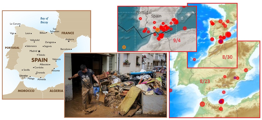
- "We left it in God's hands": Floods
Wreck Spanish Seaside Town
September 2, 2021
https://www.theguardian.com/world/2021/sep/02/floods-devastate-spanish-town
- People in the town of Alcanar in
north-east Spain have been assessing the damage caused to
homes and businesses by flooding produced by intense rain
that fell over large areas of the country. Other parts of
Spain's central and northern areas, including Madrid, also
experienced flooding.
ZetaTalk Prediction
12/4/2010: The
roll of Africa, as we have described, will be more of a twist
in place. The plate overall drops enough that having the top
part shift to the east does not do damage along the plate
boundaries. The Straits of Gibraltar will open an additional
125 miles and the northern point at Morocco will move 50 miles
further east.
Landslides and ruptured roads are usually accompanied by moving
ground, not just rainfall - whether from earthquakes or being
pulled apart in a stretch zone. If water caused the damage, then
scouring from raging water is evident or long-term washing away
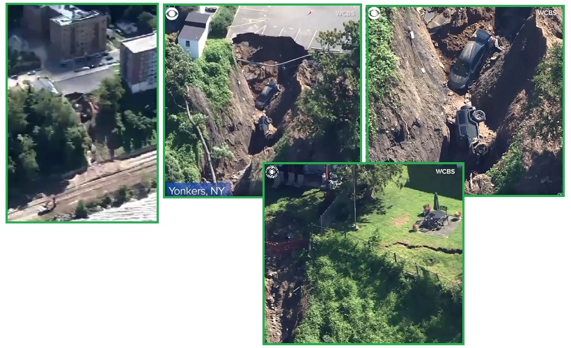
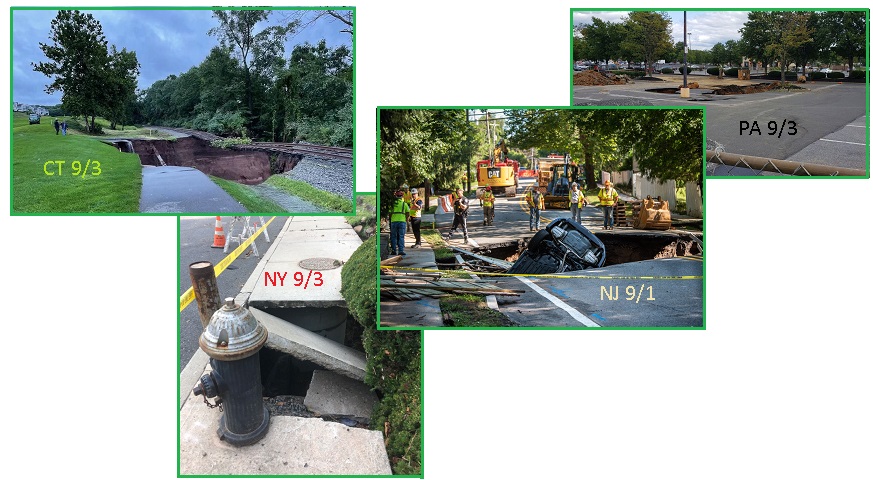
of the soil is evident. On September 3, the New
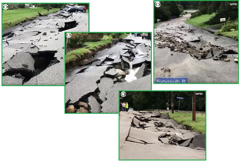
York landslide has no evidence of water damage, and the Rhode
Island street does not show water erosion in the lawns,
though it does show that heaving ground in the lawns occurred.
Sinkholes emerged in NJ,
NY,
PA,
and CT
during Wave#2, clearly not from excessive rain. This is Wave#2
once again, disguised as Ida damage.
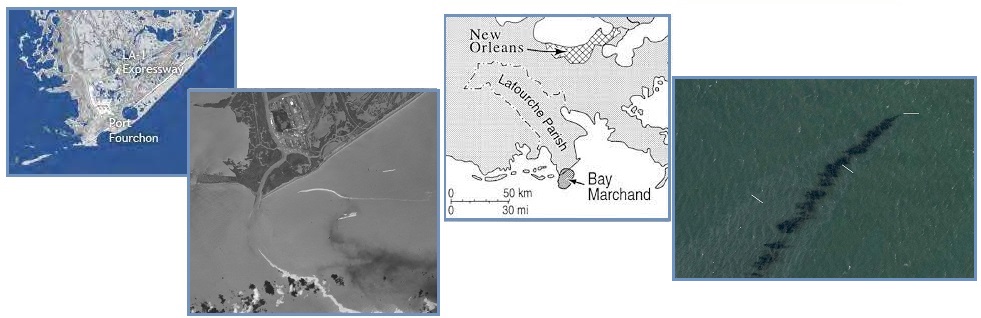
An oil spill emerged on September 2 close to New Orleans, where
the New Madrid unzipping emerges. This once again is being
blamed on the high winds of Ida, but the source of this spill is
not structures above the waves or even structures that could be
blown about by high winds. The source is deep under the water,
as was the BP Gulf oil spill in
2010. Divers soon confirmed that this oil spill was from a
broken pipe on the Gulf floor, ruptured by ground movement.
- Cleanup Boats on Scene of Large Gulf
Oil Spill Following Ida
September 2, 2021
https://www.yahoo.com/news/cleanup-boats-scene-large-gulf
- An oil slick is shown on Sept. 2,
2021 south of Port Fourchon, La. The U.S. Coast Guard said
Saturday, Sept. 4, that cleanup crews are responding to a
sizable oil spill in the Gulf of Mexico following
Hurricane Ida. The spill, which is ongoing, appears to be
coming from a source underwater at an offshore drilling
lease about two miles (three kilometers) south of Port
Fourchon, Louisiana.
- Divers to Try to Locate Source of
Reported Oil Spill in Gulf after Hurricane Ida
September 4, 2021
https://www.yahoo.com/news/divers-try-locate-source-reported
- A private dive team will try to
locate the source of a suspected oil spill spotted in the
Bay Marchand area of the Gulf of Mexico. Images showed a
miles-long brownish-black slick spreading in coastal
waters about two miles off Port Fourchon, Louisiana, an
oil and gas hub.
- Divers Point to a Broken Pipeline as
the Source of the Gulf Oil Spill
September 5, 2021
https://www.npr.org/2021/09/05/1034519831/divers-point-to-a-broken-pipeline-as-the-source-of-the-gulf-oil-spill
- Divers at the site of an ongoing
oil spill that appeared in the Gulf of Mexico after
Hurricane Ida have identified the apparent source as
one-foot diameter pipeline displaced from a trench on the
ocean floor and broken open.
On September 4 Montgomery County, Tennessee experienced a boom
and shaking from what is being called an "unknown phenomena".
There were earthquakes in the area the day before and after this
episode. An additional earthquake also registered off-shore from
the East Coast on September 6. The SE Portion is indeed being
tugged to stay in place.
- "Unknown phenomena" caused Ground to
Shake in Clarksville
September 5, 2021
https://www.wkrn.com/news/unknown-phenomena-caused-ground-to-shake-in-clarksville-police-say/
- Multiple agencies in Montgomery
County spent hours searching for the source of an "unknown
phenomena" that involved reports of a loud explosion and
the ground shaking.
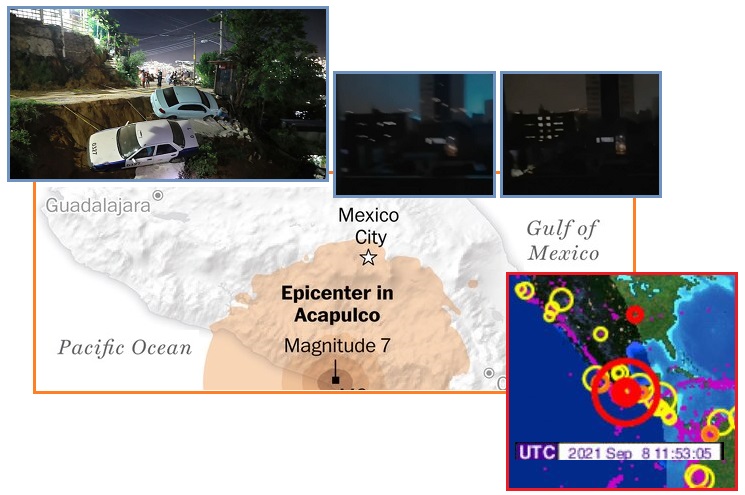
Wave#3 Begins
Then on September 8 the tip
of Mexico - the start of the New Madrid Fault Line -
had a massive 7.3 quake. Earthquake
lights filled the sky in Mexico City. The Zetas had
advised to watch the tip of Mexico for clues as to when the New
Madrid adjustment might occur. This Mexico quake went
hand-in-hand with a significant quake at New Madrid. Is this the
start of Wave#3 from the Gulf? Wave#2 might have been slow-mo
but Wave#3 appears to have started with a bang.
ZetaTalk Prediction
8/28/2010: Mexico
will lurch to the west as this major quake occurs, with a
settling of land to the west of the Mississippi almost
instantly afterwards. The Mississippi will seem to have
widened, and those to the West will see a new view as they
look East, as their land will have shifted to the Southwest as
well as dropped.
ZetaTalk Prediction
1/31/2020: The
nudge against the N American Plate at the tip of Mexico that
we have predicted will trigger the New Madrid adjustment.
|