80 Foot Elevation
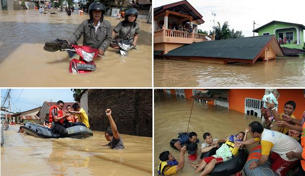
Where the sinking of the plate tongue holding Indonesia is proceeding in an uneven manner, amid crumbling of the land, the
island of Java has sunk to the level of 80 feet on both ends by early April, per recent evidence. There is a cover-up in the
media in Indonesia, blaming rain, high tides, and poor drainage. There is increasing mention of evacuated residents being
relocated, and not being able to return home. The swath of impact was highlighted by an article complaining about the degree
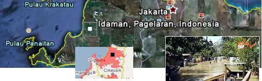
of intractable flooding in Java. Note that the "worst location" mentioned, Idaman, is 22 meters (68 feet) above sea level. This
is in the extreme west on the island of Java, near Pandeglan. Sinking in this region has been ongoing for some weeks, is
widespread, and is not subsiding. Sometimes the press calls this subsidence of the land, implying a weak point in the soil.
Sinking is a forbidden word.
- Floods in Pandeglang Not Turned Away
April 1, 2011
http://berita.liputan6.com/daerah/201104/327272/banjir_di_pandeglang_belum_surut
- Floods in Pandeglang, Banten Province, until Friday (1 / 4) has not subsided. It has been five days due to
flooding of two rivers overflow it, soak thousands of homes in seven districts in Pandeglang.
As pointed out on the Pole Shift ning, the flooding spreads from one end of the island to the other, and beyond to Papua
New Guinea.
- Flooding Spreads to the Corner of State
April 01, 2011
http://act.eramuslim.com/berita/detail/765/banjir-meluas-ke-penjuru-negeri.htm
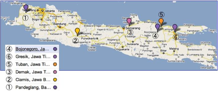
- Widespread flooding to parts of the country. Ciamis, Pandeglang, Demak, Tuban, Gresik, Bojonegoro,
Gorontalo, West Nusa Tenggara, Papua, and the last field. Pandeglang floods cause for serious concern.
Thousands of homes submerged since last week and almost no meaningful assistance from any party. Worst
location in the Village Idaman, District Patiak. Almost the entire population of 450 villages inundated. To
reach the site can only be reached by boat as far as 5 km or 1 hour away by boat rowing. In addition to the
Surianeun, Idaman and Prime, floods also soak Cimoyan Village (301 households), Babakan Kusik (136
families), Ciawi (270 families), Patiak (126 families), Rahayu (74 families).
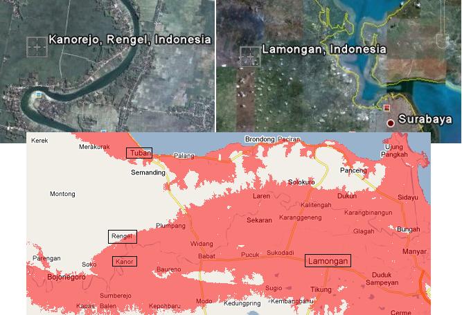
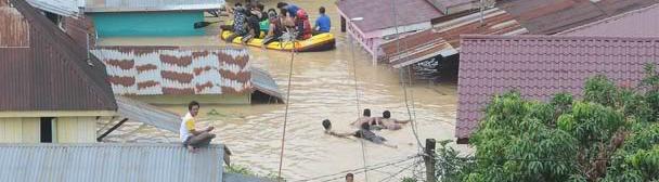
Where the flooding in the east is devastating, the flood waters not subsiding in east Java near Rengel are also at the 80 foot
level, rising to the level of 15-39 meters (45 to 108 feet), per Google Earth analysis. This area can also inundate from the sea,
particularly as a backwash of the Solo River. The areas mentioned in the article below are at or greater than the 80 foot level
- Kanorejo 39 m (117 feet), Karangtinoto 29 m (87 feet), Tambakrejo 13 m (39 feet), Bulurejo 11 m (33 feet), Sawahan 25
m (75 feet), Maibit 24 m (72 feet), Ngadirejo 15 m (45 feet)
- 1000 Hectares of Agricultural Areas in Tuban Still Awash
April 3, 2011
http://www.mediaindonesia.com/read/2011/04/03/214964/
- Although the Solo River water discharge is below the screen, but at least 1,000 hectares (ha) of agricultural
area in the eight villages in the district Rengel, Tuban, East Java are still inundated with water levels up to 50
centimeters (cm). This condition, making hundreds of farmers in the region complain plant crop failures., You
see, the floods have been soaking the land around the last week. Eight villages flooded agricultural areas that
include Kanorejo, Karangtinoto, Tambakrejo, Bulurejo, Sawahan, Maibit, Ngadirejo, and parts of Rengel.
Lamongan is under water to this level and is nowhere near the Solo River or any other river. This is sinking. Lamongan, also,
is close to the 80 foot level mentioned by the Zetas for Java. Lamongan is 28 meters (84 feet) above sea level. Lamongan
has been in the news since February 20, 2011 for flooding, and this has not subsided! Flooding in Greski, which is on the
coastline there, has been reported since March 13, 2011. That this region of Java has been sinking has never been officially
admitted.
- Lamongan Flood Victims Clean Water Crisis
April 3, 2011
http://www.metrotvnews.com/metromain/news/2011/04/03/47421/
- Thousands of flood victims in five districts in Lamongan, East Java, began to clean water crisis. They had to
use flood water for their daily needs, such as bathing, washing clothes and dishes. Jero Bengawan River flood
submerging five districts, namely Kalitengah, Turi, Karangbinangun, Deket and Glagah. Water level reached
20 centimeters to more than 0.5 meters. Flooding has been going on for two weeks.
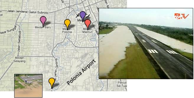
Medan, on the east coast of Sumatra, is another example. Medan experienced flooding early in the sinking process, on
February 21, 2011. Medan has access to the sea via lowlands along the coast.
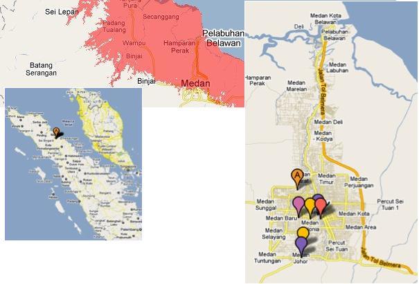
Medan got into the news because of its size, so we were uncertain of the condition of the regions closer to the coastline in
February when reports began. What we do know is that Medan was reported to have flooded even when no rain had
occurred.
Now Medan is in the news again on April 1, 2011. As the third largest city in Indonesia, this could hardly be overlooked,
even during a cover-up of the sinking in Indonesia. As a result of the most recent flooding, the water crept up to threaten the
city proper, places such as the Polonia Airport which is 30 meters (90 feet) above sea level. Medan itself rides at an average
of 26 meters (78 feet) above sea level.
- Road-Main Street of Medan Awash
April 01, 2011
http://regional.kompas.com/read/2011/04/01/11381414/Jalan-Jalan.Utama.Kota.Medan.Terendam
- The main streets in the city of Medan submerged due to the widespread flooding that occurred in the city of
Medan. Mansour Street, for example, submerged up to waist adults. A number of people reporting high water
on the road in front of Mansour North Sumatra University (USU) have reached an adult's chest.
Fukushima's Slow Death
The Zetas stated that benign aliens stepped in to prevent the Fukushima nuclear power plants from becoming another
Chernobyl, as outlined in Issue 233 of this newsletter on March 20, 2011. But complete protection was not done as a
message needed to be sent to the establishment.
ZetaTalk Statement 3/19/2011:Have benign aliens been allowed to interfere with the Japanese power plant
meltdown, limiting the damage? Yes, but they have not interfered to the degree possible, for the following reasons. It
would have been beyond a Chernobyl, affecting not only the islands of Japan but also anywhere the winds would
drift, including Hawaii and the West Coast of the US and beyond.
Problems with the Fukushima plant in Japan began when the earthquake knocked out electricity to the area, and the diesel
run backup generators failed when flooded by the tsunami. Even though the cooling rods were inserted, a reactor in
shut-down status still needs to be cooled by water. The lack of electricity prevented pumps from running, and reactor 1-3 of
the 6 suffered at least partial melt-down. Melt-down can result in super-heated material that can explode, releasing
radioactive dust into the atmosphere. Cracked structures also exist, leaking radioactive water into the area, and into the sea.
Radioactive material has been found in the ground water and soil around Fukushima. The end is no yet in sight!
- Japan's Nuclear Crisis
March 31, 2011
http://www.cnn.com/2011/WORLD/asiapcf/03/29/japan.nuclear.leaks/index.html
- Despite the heroic efforts of technicians and engineers battling to prevent a full nuclear meltdown at the
quake-damaged Fukushima Daiichi plant, radioactive material is still seeping into the surroundings of the
power station. Plutonium has been detected in soil samples near the plant. And highly radioactive water has
been found for the first time outside one of the reactor buildings on Monday, albeit in a tunnel. Radioactive
iodine and cesium have also been detected in sea water near the plant. These latest reports of radioactive
leaks - and the possibility that there may have been a partial meltdown in three reactors - raise questions
about the immediate dangers poised to human health and the environment.
How bad will it get, and will benign aliens be allowed to intervene again?
ZetaTalk Explanation 4/2/2011: The lessons that Fukushima holds for the establishment are being continued! The
Japanese government in particular has resisted admitting the reality of what was happening at Fukushima. Only
when the hard facts were in the hands of the public did they admit what was happening to the reactors which were in
the process of slow meltdown. The full facts are still not known to the public. Many deaths will result from the
Japanese government sending in workers to their certain death, all to save face and attempt to save the reactors.
These were financial decisions, as well as face saving maneuvers, none of which are gaining the sympathy of the
benign aliens who helped moderate the disaster during the quake. Thus the reactors are being allowed to proceed in
their death march, as the area will be too radioactive for operators, the two working reactors buried alive along
with the four that are disabled.
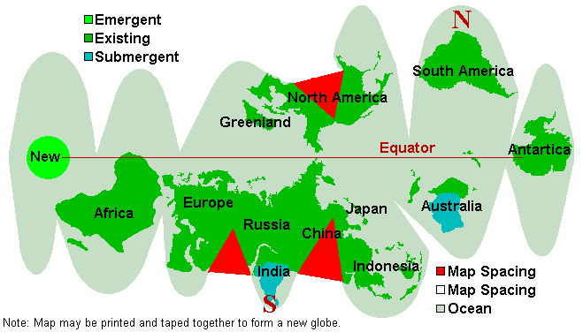
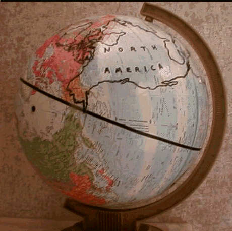
New Geography Confusion
The ZetaTalk New Geography map has been on the web since the start of ZetaTalk, based on the words given by the Zetas
and guidance to Nancy, who generated this map in PC Paintbrush. Cut along the edges, past around a small ball, and there
you have the new globe. But questions kept arising from those who complained they were not able to determine their future
Lat/Long effectively.
Your future map and other discussions mention the new N Pole off the eastern tip of Brazil, but this
map made into a globe: shows that it would be highly misleading to characterize the new N Pole as
anywhere near Brazil, because it is shown as west of the present southern tip of Africa. Would it be
too much trouble to give the present longitude and latitude of what will be the future N Pole? Would
the Zetas mind giving the present latitude and longitude of the future N Pole?
So the new Lat/Long of the poles was given:
ZetaTalk Answer 7/17/2010: Under our direction Nancy has ascertained via Google Earth that the new N Pole will
be at the current lat/long of 5°S and 29°W and the new S Pole will be the current lat/long of 10°N and 78°E. These
points are not on opposites of the globe from one another today. The Pacific compresses, the Atlantic widens, the S
America Plate crunches through much of what is now the Caribbean Plate, and all this and more reform the globe
somewhat so that geographical points are not relative to other geographical points as they are today.
But confusion still ran rampant. In their response to this confusion, the Zetas stated that it was not for lack of explanation on
their part, but that the shock of a new globe was too much, and the complainants were thus refusing to visualize the new
globe, even when it was in front of them. The new globe had already been superimposed on an existing globe, as part of the
Pole Shift TEAM efforts.
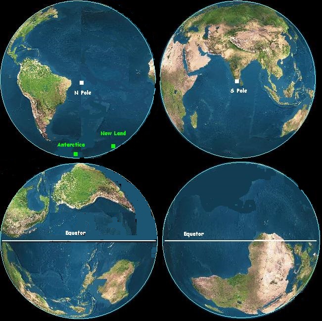
The map at New Geography shows the new positions of the equator and the poles after the pole shift.
On that map, the new equator goes thru the old South Pole. Every equator is a great circle of a
sphere, and so if the new equator goes thru the old South Pole, then - as a great circle - it must also
pass thru its' antipode at the old North Pole. But, since the poles are on a diameter, that fact does not
determine the old longitude of the new equator.
ZetaTalk Response 10/16/2010: What is left is for you to be able to conceptualize this matter, and not be rigid in
your mindset. We have stated that the Pacific shortens, primarily by folding near the Philippine Plate. The Atlantic
will rips apart, the Caribbean Plate and the tongue holding Indonesia will be pushed down or ground up. Great rifts
will develop so that an inland bay is produced from Karachi up into Russia, and the N American Seaway will widen
greatly. If it is beyond you to comprehend these changes, then simply look at the new geography depicted and say
"well, there it is".
Perhaps complaints will never stop coming, though when knowing where the new Equator will run and the exact position of
the new poles and where the new continents will be when superimposed upon a globe, one can estimate that Latitude of their
new geography. But complaints continued. This time, the Zetas led them by the hand. I, Nancy, have since followed their
directions, using images from Fourmilab to produced a 2D image. But since denial and shock are with us still, I don't expect
this to end the questions.
I have a question about the overall movement of the two American continents during the PS. Right
now, they are in a certain relationship to each other (longitudinally speaking). For example, right
now New York City is directly north of Bogota, Colombia. Can the Zetas give us a better idea of just
how much further to the west (and north?) the SA continent will move in relationship to the NA
continent during the PS?
ZetaTalk Comments 4/2/2011: Apparently, nothing short of a new globe, drawn by ourselves, will suffice. All you
have to do is buy a cheap globe, trace the continents on a piece of paper and cut them out ready to paste, paint the
globe so it is a blank, and paste the continents in their appropriate places aka Nancy's map and Mike's globe photos.
Simple. Why is there this continuing confusion? This is at base a gasp of disbelief. One does not want to contemplate
such radical changes, so one simply does not grasp the outcome. The outcome is what should be focused on, for
understanding.
Andrew's Video
Andrew, a staunch member of the Pole Shift ning Has produced two videos explaining the pole shift. The first deals with the
historical evidence of prior pole shifts, and is over 2:30 hours in length. The second, newly released, deals with the current
signs that we are in another passage, and is 2:37 hours in length. Both are fact filled and highly recommended.
You received this Newsletter because you subscribed to the ZetaTalk Newsletter service. If undesired, you can quickly Unsubscribe.
|